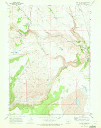
1968 Map of Sage Hen Butte
USGS Topo · Published 1972About this map
Sage Hen Butte dominates this high-desert landscape in southeastern Oregon, standing as a prominent landmark within the Fremont National Forest. This 1968 field-checked survey reveals a remote cattle-grazing and seasonal-living environment, marked by isolated structures such as Thompson Cabin, Wakefield Cabin, and the Schadler Cow Camp. The map documents a complex hydrological network including Parsnip Creek and Crane Creek, which feed into ephemeral water bodies like Crane Lake and the significant basin of Big Lake in the southeast. Cultural features are sparse but telling of the era's land use, showing a network of jeep trails connecting remote outposts and water sources. Researchers will find interest in the specific locations of a Borrow Pit and various prospect points, alongside established landmarks like Sage Hen Crossing.
Find a feature on this map
30 named features on this map. Tap any name to fly to it.
Don’t see what you’re looking for? This feature index may not catch every label — zoom into the map to look around manually.
Map Details
Editions of this 1968 Sage Hen Butte Map
This is the sole edition of this map. No revisions or reprints were ever made.
Other maps of this area

1955 · Klamath Falls
USGS Topo · 1:250,000

1955 · Adel
USGS Topo · 1:250,000

1957 · Adel
USGS Topo · 1:250,000

1958 · Klamath Falls
USGS Topo · 1:250,000

1958 · Adel
USGS Topo · 1:250,000

1962 · Adel
USGS Topo · 1:250,000

1967 · Priday Reservoir
USGS Topo · 1:24,000

1968 · Crook Peak
USGS Topo · 1:24,000
1968 · Horse Prairie
USGS Topo · 1:24,000
1968 · May Lake
USGS Topo · 1:24,000