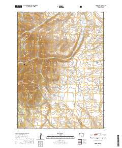
2020 Map of Drake Peak
USGS Topo · Published 2020About this map
Drake Peak anchors the western edge of this landscape within the Fremont National Forest, overlooking a network of high-elevation creek drainages and springs. The terrain is defined by the descent from Peddlers Ridge toward the southeast, where seasonal and managed water sources like Thompson Lake and Game Reservoir suggest the importance of water management in this arid region. The drainage patterns of Twelvemile Cr, McDowell Cr, and Snipe Cr illustrate the complex watershed geography of the Warner Mountains. Evidence of local land use appears in the naming of remote water sources such as Obernolte Spring and Deboy Reservoir. These features, alongside the Plush Cutoff Rd, highlight the infrastructure supporting ranching and wildlife management in this corner of Lake County.
Find a feature on this map
26 named features on this map. Tap any name to fly to it.
Don’t see what you’re looking for? This feature index may not catch every label — zoom into the map to look around manually.
Map Details
Editions of this 2020 Drake Peak Map
This is the sole edition of this map. No revisions or reprints were ever made.
Other maps of this area

1955 · Klamath Falls
USGS Topo · 1:250,000

1955 · Adel
USGS Topo · 1:250,000

1957 · Adel
USGS Topo · 1:250,000

1958 · Klamath Falls
USGS Topo · 1:250,000

1958 · Adel
USGS Topo · 1:250,000

1962 · Adel
USGS Topo · 1:250,000

1967 · Plush
USGS Topo · 1:24,000

1967 · Priday Reservoir
USGS Topo · 1:24,000
1968 · Sage Hen Butte
USGS Topo · 1:24,000

1968 · Crook Peak
USGS Topo · 1:24,000