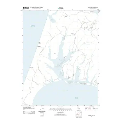
2012 Map of Drakes Bay
USGS Topo · Published 2012About this map
H Ranch, M Ranch, and Home Ranch are prominent features in this coastal landscape, reflecting the long-standing agricultural tradition of the Marin County peninsula. The intricate system of waterways, including Drakes Estero and its branching inlets like Schooner Bay and Creamery Bay, dominates the central portion of the map. These estuarine waters are protected by landforms such as Bull Point and the narrow Limantour Spit, which separates the inner bay from the open Pacific Ocean. On the eastern edge, Inverness Ridge provides a significant change in elevation compared to the coastal lowlands. This survey illustrates the proximity of working ranch lands to the protected boundaries of Point Reyes National Seashore, showing the coexistence of private enterprise and public preservation in the early 21st century. Infrastructure remains centered around historical sites like Schooner Landing and a Blacksmith Shop near Rogers Ranch.
Find a feature on this map
36 named features on this map. Tap any name to fly to it.
Don’t see what you’re looking for? This feature index may not catch every label — zoom into the map to look around manually.
Map Details
Editions of this 2012 Drakes Bay Map
This is the sole edition of this map. No revisions or reprints were ever made.
Other maps of this area

1916 · Point Reyes
USGS Topo · 1:48,000

1918 · Point Reyes
USGS Topo · 1:62,500

1947 · Santa Rosa
USGS Topo · 1:250,000

1947 · San Francisco
USGS Topo · 1:250,000

1948 · San Francisco
USGS Topo · 1:250,000

1949 · Santa Rosa
USGS Topo · 1:250,000

1953 · Drakes Bay
USGS Topo · 1:24,000
1954 · Point Reyes NE
USGS Topo · 1:24,000
1954 · Inverness
USGS Topo · 1:24,000
1954 · Tomales
USGS Topo · 1:24,000