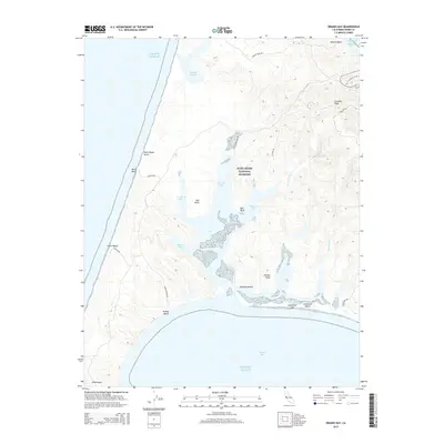
2015 Map of Drakes Bay
USGS Topo · Published 2015About this map
Point Reyes National Seashore dominates this coastal landscape, protecting a complex network of bays, esteros, and ridges. The topography is defined by the sharp rise of Inverness Ridge to the east and the expansive Pacific Ocean to the west. Between these features lies a delicate system of tidal waters including Schooner Bay, Creamery Bay, and Home Bay, separated by points of land such as Bull Point. The southern coast is marked by the long, sandy reach of Limantour Spit and the distinctive landmark of Drakes Head. The interior drainage is managed by small coastal streams like Home Ranch Cr and Glenbrook Cr, which feed into the esteros. Traces of human activity are present via roads such as Pierce Point Rd and Limantour Rd, providing access to remote locations like Abbotts Lagoon and the windswept Point Reyes Beach.
Find a feature on this map
32 named features on this map. Tap any name to fly to it.
Don’t see what you’re looking for? This feature index may not catch every label — zoom into the map to look around manually.
Map Details
Editions of this 2015 Drakes Bay Map
This is the sole edition of this map. No revisions or reprints were ever made.
Other maps of this area

1916 · Point Reyes
USGS Topo · 1:48,000

1918 · Point Reyes
USGS Topo · 1:62,500

1947 · Santa Rosa
USGS Topo · 1:250,000

1947 · San Francisco
USGS Topo · 1:250,000

1948 · San Francisco
USGS Topo · 1:250,000

1949 · Santa Rosa
USGS Topo · 1:250,000

1953 · Drakes Bay
USGS Topo · 1:24,000
1954 · Point Reyes NE
USGS Topo · 1:24,000
1954 · Inverness
USGS Topo · 1:24,000
1954 · Tomales
USGS Topo · 1:24,000