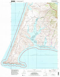
1995 Map of Drakes Bay
USGS Topo · Published 2000About this map
Point Reyes reaches into the Pacific Ocean on this coastal study, defined by the intricate finger-like inlets of Drakes Estero and Estero de Limantour. The landscape is a mix of protected wilderness within the Point Reyes National Seashore and legacy agricultural operations, represented by family-named holdings such as H Ranch, M Ranch, and Home Ranch. These cattle and dairy operations, established in the nineteenth century, remain visible alongside modern navigational aids like the Lighthouse and several Radio Towers. Remnants of earlier maritime and shore-based activity are documented at the Schooner Ldg (Site) and a Blacksmith Shop (Site). The map tracks the transition from the high Sand Dunes near Abbotts Lagoon to the dramatic cliffs of Sea Lion Cove and Chimney Rock, connected by the winding Sir Francis Drake Highway.
Find a feature on this map
37 named features on this map. Tap any name to fly to it.
Don’t see what you’re looking for? This feature index may not catch every label — zoom into the map to look around manually.
Map Details
Editions of this 1995 Drakes Bay Map
This is the sole edition of this map. No revisions or reprints were ever made.
Other maps of this area

1916 · Point Reyes
USGS Topo · 1:48,000

1918 · Point Reyes
USGS Topo · 1:62,500

1947 · Santa Rosa
USGS Topo · 1:250,000

1947 · San Francisco
USGS Topo · 1:250,000

1948 · San Francisco
USGS Topo · 1:250,000

1949 · Santa Rosa
USGS Topo · 1:250,000

1953 · Drakes Bay
USGS Topo · 1:24,000
1954 · Point Reyes NE
USGS Topo · 1:24,000
1954 · Inverness
USGS Topo · 1:24,000
1954 · Tomales
USGS Topo · 1:24,000