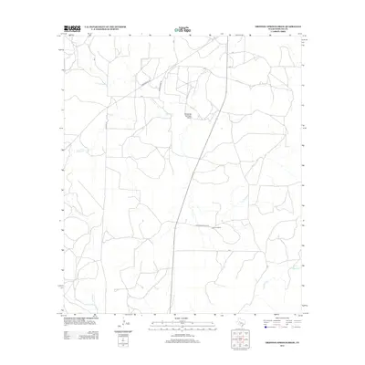
2012 Map of Dripping Springs Draw
USGS Topo · Published 2012About this map
Santa Fe Ranch and various ranching corridors define this segment of Sterling County, where the landscape is etched by seasonal watercourses like Dripping Springs Draw and Sterling Cr. This survey captures the rural infrastructure of West Texas in the early 2010s, marked by a network of private roads and secondary routes such as Marvin Foster Rd and Ranch Road 2139. The drainage patterns of Kiowa Cr in the southwest and Mulberry Cr in the southeast underscore the reliance on natural draws in this arid territory. This topographic record is essential for understanding modern land use and historical property boundaries in the region, particularly for those tracing the development of established ranch lands.
Find a feature on this map
16 named features on this map. Tap any name to fly to it.
Don’t see what you’re looking for? This feature index may not catch every label — zoom into the map to look around manually.
Map Details
Editions of this 2012 Dripping Springs Draw Map
This is the sole edition of this map. No revisions or reprints were ever made.
Other maps of this area

1954 · San Angelo
USGS Topo · 1:250,000

1958 · San Angelo
USGS Topo · 1:250,000

1963 · Cumbie Draw
USGS Topo · 1:24,000

1963 · Glass Ranch
USGS Topo · 1:24,000

1965 · San Angelo
USGS Topo · 1:250,000

1972 · Sterling City
USGS Topo · 1:24,000

1972 · Dog Creek SW
USGS Topo · 1:24,000

1972 · Dog Creek NW
USGS Topo · 1:24,000

1973 · Hay Hollow
USGS Topo · 1:24,000
1973 · Coon Dive Draw
USGS Topo · 1:24,000