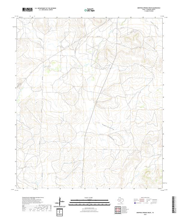
2022 Map of Dripping Springs Draw
USGS Topo · Published 2022About this map
Sterling Cr and Dripping Springs Draw define the drainage patterns of this Sterling County landscape, where the high plateau of West Texas is dissected by seasonal watercourses. The map reveals a transition from traditional ranching routes to modern rural infrastructure, characterized by long, straight sections of Fm 2139 and the network of county roads including Co RD 104-P and Co RD 116-P. Local transit is guided by family-named landmarks and historical property lines, as seen in the alignment of Jackson Ln and Marvin Foster Rd. The terrain is marked by significant topographic relief in the east, where James Hollow and the headwaters of Mulberry Cr cut deep into the limestone caprock, creating a complex series of ridges and draws that contrast with the more open country to the west.
Find a feature on this map
17 named features on this map. Tap any name to fly to it.
Don’t see what you’re looking for? This feature index may not catch every label — zoom into the map to look around manually.
Map Details
Editions of this 2022 Dripping Springs Draw Map
This is the sole edition of this map. No revisions or reprints were ever made.
Other maps of this area

1954 · San Angelo
USGS Topo · 1:250,000

1958 · San Angelo
USGS Topo · 1:250,000

1963 · Cumbie Draw
USGS Topo · 1:24,000

1963 · Glass Ranch
USGS Topo · 1:24,000

1965 · San Angelo
USGS Topo · 1:250,000

1972 · Sterling City
USGS Topo · 1:24,000

1972 · Dog Creek SW
USGS Topo · 1:24,000

1972 · Dog Creek NW
USGS Topo · 1:24,000

1973 · Hay Hollow
USGS Topo · 1:24,000
1973 · Coon Dive Draw
USGS Topo · 1:24,000