
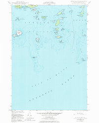
1948 Map of Drisko Island
USGS Topo · Published 1969About this map
Gulf of Maine waters surround a dense archipelago of islands and ledges in this maritime study of the Washington County coastline. The landscape is dominated by named landforms such as Drisko Island, Big Nash Island, and the narrow crossing at Tibbett Narrows. This chart reflects hydrographic surveys dating back to 1870, combined with 1940s aerial photography, to document the intricate shoreline of Pleasant Bay and Beals Bay.
Find a feature on this map
44 named features on this map. Tap any name to fly to it.
Don’t see what you’re looking for? This feature index may not catch every label — zoom into the map to look around manually.
Map Details
Editions of this 1948 Drisko Island Map
2 editions found
Other maps of this area

1902 · Cherryfield
USGS Topo · 1:62,500

1904 · Cherryfield
USGS Topo · 1:62,500

1904 · Petit Manan
USGS Topo · 1:62,500

1921 · Great Wass Island
USGS Topo · 1:62,500

1921 · Columbia Falls
USGS Topo · 1:62,500

1941 · Columbia Falls
USGS Topo · 1:62,500

1942 · Cherryfield
USGS Topo · 1:62,500

1942 · Columbia Falls
USGS Topo · 1:62,500

1948 · Jonesport
USGS Topo · 1:24,000
1948 · Harrington
USGS Topo · 1:24,000