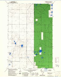
1971 Map of Drummond NW
USGS Topo · Published 1985About this map
Chequamegon National Forest dominates the eastern half of this landscape, managed through the Washburn District Ranger. This northern Wisconsin terrain is defined by a dense concentration of glacial kettle lakes and wetlands, connected by a network of forest roads and hiking paths. The North Country Trail winds through the northern section, passing near Lake Ruth and Camp Two Lake, while the southern reaches are marked by more secluded waters like Wilderness Lake and Nancy Lake. In the west, the landscape transitions to a more open pattern of ridges and depressions, where West Eightmile Lake and East Eightmile Lake sit along the path of Webster Road. This survey, updated with 1980s forest service data, captures a quiet era of recreational and timber management before modern development altered these shorelines.
Find a feature on this map
21 named features on this map. Tap any name to fly to it.
Don’t see what you’re looking for? This feature index may not catch every label — zoom into the map to look around manually.
Map Details
Editions of this 1971 Drummond NW Map
2 editions found
Other maps of this area

1943 · Iron Lake
USGS Topo · 1:48,000

1944 · Drummond
USGS Topo · 1:48,000

1945 · Highland
USGS Topo · 1:48,000

1947 · Drummond
USGS Topo · 1:48,000

1947 · Brule
USGS Topo · 1:48,000

1947 · Iron Lake
USGS Topo · 1:48,000

1949 · Highland
USGS Topo · 1:48,000

1953 · Ashland
USGS Topo · 1:250,000

1958 · Ashland
USGS Topo · 1:250,000

1961 · Iron Lake SW
USGS Topo · 1:24,000