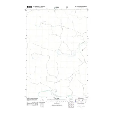
2011 Map of Dry Bullion Creek
USGS Topo · Published 2011About this map
The Little Missouri River meanders across the southern portion of this landscape, defining the local drainage and topography in Golden Valley County. This 2011 survey documents a sparsely populated ranching environment where large landholdings like the Van Daele Ranch, Wajahn Ranch, and Howard Ranch serve as primary landmarks. The network of waterways, including Bullion Creek, Dry Bullion Creek, and the smaller Dry Creek, reveals the dendritic erosion patterns characteristic of the North Dakota badlands. Transport is facilitated by rural routes such as 477th St Sw and Van Daele Rd, which connect these remote ranch sites to the wider region. The map provides a detailed view of the terrain just before modern digital mapping standards became more centralized, preserving the specific placement of these family-named operations.
Find a feature on this map
9 named features on this map. Tap any name to fly to it.
Don’t see what you’re looking for? This feature index may not catch every label — zoom into the map to look around manually.
Map Details
Editions of this 2011 Dry Bullion Creek Map
This is the sole edition of this map. No revisions or reprints were ever made.
Other maps of this area

1953 · Dickinson
USGS Topo · 1:250,000

1957 · Dickinson
USGS Topo · 1:250,000

1979 · Deep Creek North
USGS Topo · 1:24,000

1979 · Sentinel Butte SE
USGS Topo · 1:24,000

1979 · Three V Crossing
USGS Topo · 1:24,000
1979 · Chimney Butte
USGS Topo · 1:24,000

1979 · Square Butte
USGS Topo · 1:24,000

1979 · Bullion Butte
USGS Topo · 1:24,000

1980 · Spring Creek
USGS Topo · 1:24,000

1980 · Alpha
USGS Topo · 1:24,000