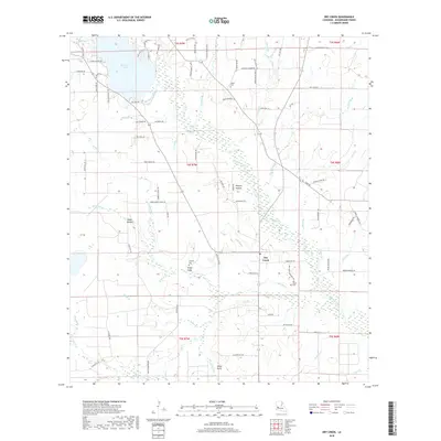
2018 Map of Dry Creek
USGS Topo · Published 2018About this map
Dry Creek and its surrounding wetlands define this portion of Beauregard Parish, where a dense network of tributaries like Bundick Creek and Mill Bayou feed into Bundick Lake. This 2018 survey reveals a landscape shaped by both water and timber history, evident in family-named corridors such as Tommy Bailey Rd and Odis Greene Rd. Local genealogy is well-represented through multiple burial grounds, including Dry Creek Cem, Shiloh Cem, and Lindsey Cem. The terrain is characterized by specific landforms like Steep Gully and Miller Gully, which break up the low-lying wetlands. Smaller settlements such as Hickory Hollow and Camp Hollow are connected by a grid of parish roads and historical routes like Old Tram Rd, indicating the area's legacy of forestry and rural transit.
Find a feature on this map
97 named features on this map. Tap any name to fly to it.
Don’t see what you’re looking for? This feature index may not catch every label — zoom into the map to look around manually.
Map Details
Editions of this 2018 Dry Creek Map
This is the sole edition of this map. No revisions or reprints were ever made.
Other maps of this area

1935 · Mittie
USGS Topo · 1:31,680

1935 · Longville
USGS Topo · 1:31,680

1947 · Le Blanc
USGS Topo · 1:31,680

1947 · Ikes
USGS Topo · 1:31,680

1947 · Reeves
USGS Topo · 1:31,680

1947 · Longville
USGS Topo · 1:31,680

1947 · Grant
USGS Topo · 1:31,680

1947 · Bundick
USGS Topo · 1:31,680

1947 · Sugartown
USGS Topo · 1:31,680

1947 · Bannister
USGS Topo · 1:31,680