
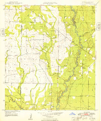
1947 Map of Sugartown
USGS Topo · Published 1947About this map
Sugartown serves as the focal point for this landscape in Beauregard Parish, situated at the junction of several early state highways. The map reveals a region defined by its timber industry and complex drainage systems, where a Logging Railroad and an Old Logging Railroad Grade cut diagonally across the terrain, indicating the historical movement of lumber toward distant mills.
Find a feature on this map
31 named features on this map. Tap any name to fly to it.
Don’t see what you’re looking for? This feature index may not catch every label — zoom into the map to look around manually.
Map Details
Editions of this 1947 Sugartown Map
This is the sole edition of this map. No revisions or reprints were ever made.
Other maps of this area

1935 · Mittie
USGS Topo · 1:31,680

1947 · Ikes
USGS Topo · 1:31,680

1947 · Chasmore
USGS Topo · 1:31,680

1947 · Grant
USGS Topo · 1:31,680

1947 · Bundick
USGS Topo · 1:31,680

1947 · Bannister
USGS Topo · 1:31,680

1947 · Sugrue
USGS Topo · 1:31,680

1947 · Pitkin
USGS Topo · 1:31,680

1948 · Grant
USGS Topo · 1:24,000
1948 · Mittie
USGS Topo · 1:24,000