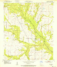
1950 Map of Dry Creek
USGS Topo · Published 1952About this map
Bundick Creek and its many meandering tributaries define the landscape of this portion of Beauregard Parish at the midpoint of the twentieth century. The settlement of Dry Creek serves as a local hub, featuring the Dry Creek Cem and a nearby Gaging Station on the water. The map detail reflects a rural society organized around small communities and religious centers, such as Shiloh Ch and Welcome Ch. Numerous family-named waterways like Walter Miller Gully and Weeks Branch suggest long-standing land ownership patterns and a landscape shaped by local agriculture and forestry. The drainage network, including Little Dry Creek and Crooked Creek, illustrates the complex hydrology of the Louisiana piney woods before later twentieth-century development altered many of these smaller rural environments.
Find a feature on this map
37 named features on this map. Tap any name to fly to it.
Don’t see what you’re looking for? This feature index may not catch every label — zoom into the map to look around manually.
Map Details
Editions of this 1950 Dry Creek Map
This is the sole edition of this map. No revisions or reprints were ever made.
Other maps of this area

1935 · Mittie
USGS Topo · 1:31,680

1935 · Longville
USGS Topo · 1:31,680

1947 · Le Blanc
USGS Topo · 1:31,680

1947 · Ikes
USGS Topo · 1:31,680

1947 · Reeves
USGS Topo · 1:31,680

1947 · Longville
USGS Topo · 1:31,680

1947 · Grant
USGS Topo · 1:31,680

1947 · Bundick
USGS Topo · 1:31,680

1947 · Sugartown
USGS Topo · 1:31,680

1947 · Bannister
USGS Topo · 1:31,680