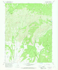
1965 Map of Dry Creek
USGS Topo · Published 1968About this map
The Grand Mesa National Forest dominates the upper reaches of this mid-1960s landscape, where the southern slopes of the mesa transition into a complex system of irrigation and resource extraction. The area’s agricultural viability is managed through an extensive network of water engineering, including the Surface Creek Ditch, Aqueduct, and Overland Canal, which divert mountain runoff toward the Redlands Mesa and Cedar Mesa.
Find a feature on this map
42 named features on this map. Tap any name to fly to it.
Don’t see what you’re looking for? This feature index may not catch every label — zoom into the map to look around manually.
Map Details
Editions of this 1965 Dry Creek Map
4 editions found
Other maps of this area

1955 · Grand Mesa
USGS Topo · 1:24,000

1955 · Lazear
USGS Topo · 1:24,000

1956 · Montrose
USGS Topo · 1:250,000

1957 · Leadville
USGS Topo · 1:250,000

1959 · Leadville
USGS Topo · 1:250,000

1959 · Montrose
USGS Topo · 1:250,000

1960 · Leadville
USGS Topo · 1:250,000

1960 · Montrose
USGS Topo · 1:250,000

1960 · Leon Peak
USGS Topo · 1:24,000

1961 · Chalk Mountain
USGS Topo · 1:24,000