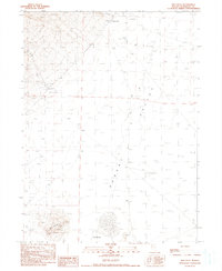
1990 Map of Dry Hills
USGS Topo · Published 1990About this map
Alexander Ridge dominates the northwestern corner of this landscape, its steep contours giving way to the expansive floor of Desert Valley. This 1990 provisional survey documents the sparse but vital water infrastructure of the Great Basin, where Willow Creek feeds into a Reservoir and Stock Pond near the Willow Creek Ranch. Further north, Alexander Ranch sits at the edge of the ridge, marking a pocket of settlement in an otherwise arid environment. The southern reaches of the quadrangle transition into a series of Dry Lakes and expansive Hardpans, indicating a terminal drainage basin. Near the Dry Hills, several marked Prospects suggest historical mineral exploration. Isolated infrastructure like Sand Dunes Well and various unnamed Windmills provide a look at the remote ranching and survey operations that defined this part of Humboldt County in the late 20th century.
Find a feature on this map
18 named features on this map. Tap any name to fly to it.
Don’t see what you’re looking for? This feature index may not catch every label — zoom into the map to look around manually.
Map Details
Editions of this 1990 Dry Hills Map
This is the sole edition of this map. No revisions or reprints were ever made.
Other maps of this area

1886 · Disaster
USGS Topo · 1:250,000

1893 · Disaster
USGS Topo · 1:250,000

1954 · Vya
USGS Topo · 1:250,000

1958 · Vya
USGS Topo · 1:250,000

1961 · Bottle Creek
USGS Topo · 1:62,500

1962 · Vya
USGS Topo · 1:250,000

1966 · Donna Schee Peak
USGS Topo · 1:62,500
1982 · Bottle Creek Slough SW
USGS Topo · 1:24,000
1982 · Presnel Well
USGS Topo · 1:24,000
1982 · Lay Waterhole
USGS Topo · 1:24,000