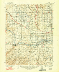
1939 Map of Duchesne
USGS Topo · Published 1949About this map
The Uinta Indian Reservation dominates the northern reaches of this landscape, where early 20th-century irrigation efforts are evident in the complex network of the Pioneer Canal, Farmers Canal, and Myton Canal. This 1930s survey reveals a dispersed settlement pattern centered around small agricultural and ranching hubs like Altonah, Mountain Home, and Mt Emmons. The southern terrain shifts into a series of deep drainages such as Indian Canyon and Antelope Canyon, leading toward the industrial site at Pariette Mine. The confluence of the Strawberry River and the Duchesne River near the town of Duchesne serves as the geographic anchor for the region. Genealogists and historians will find significant value in the identified rural sites, including Knights Ranch, Chidester Springs, and the Monarch Sch, which provide a clear record of the area's development before modern infrastructure altered these desert ranching communities.
Find a feature on this map
81 named features on this map. Tap any name to fly to it.
Don’t see what you’re looking for? This feature index may not catch every label — zoom into the map to look around manually.
Map Details
Editions of this 1939 Duchesne Map
3 editions found

Other maps of this area

1885 · East Tavaputs
USGS Topo · 1:250,000

1885 · Ashley
USGS Topo · 1:250,000

1885 · Uinta
USGS Topo · 1:250,000

1886 · Price River
USGS Topo · 1:250,000

1896 · Price River
USGS Topo · 1:250,000

1901 · Hayden Peak
USGS Topo · 1:125,000

1903 · Hayden Peak
USGS Topo · 1:125,000

1905 · Gilbert Peak
USGS Topo · 1:125,000

1906 · Gilbert Peak
USGS Topo · 1:125,000

1906 · Marsh Peak
USGS Topo · 1:125,000