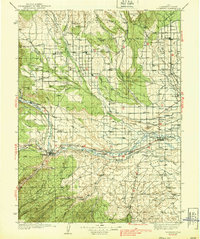
1939 Map of Duchesne
USGS Topo · Published 1939About this map
The Uinta Indian Reservation dominates the northern reaches of this 1930s survey, where a sophisticated network of irrigation works like the Uinta Canal, Blue Bench Canal, and Farmers Canal supported high-desert agriculture. The landscape is defined by its dramatic benches and washes, with the Duchesne River and Strawberry River carving through the terrain near the town of Duchesne. To the south, the terrain becomes increasingly arid and broken as it approaches Pariette Bench and Castle Peak. This era shows the region well before modern expansion, when local life revolved around small ranching hubs and isolated landmarks like Knights Ranch and the Monarch Sch. The Uinta Basin Highway serves as the primary artery connecting the established settlements of Roosevelt, Myton, and Bridgeland, revealing the early 20th-century transportation patterns of eastern Utah.
Find a feature on this map
69 named features on this map. Tap any name to fly to it.
Don’t see what you’re looking for? This feature index may not catch every label — zoom into the map to look around manually.
Map Details
Editions of this 1939 Duchesne Map
3 editions found

Other maps of this area

1885 · East Tavaputs
USGS Topo · 1:250,000

1885 · Ashley
USGS Topo · 1:250,000

1885 · Uinta
USGS Topo · 1:250,000

1886 · Price River
USGS Topo · 1:250,000

1896 · Price River
USGS Topo · 1:250,000

1901 · Hayden Peak
USGS Topo · 1:125,000

1903 · Hayden Peak
USGS Topo · 1:125,000

1905 · Gilbert Peak
USGS Topo · 1:125,000

1906 · Gilbert Peak
USGS Topo · 1:125,000

1906 · Marsh Peak
USGS Topo · 1:125,000