
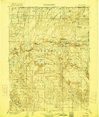
1906 Map of Gilbert Peak
USGS Topo · Published 1906About this map
Gilbert Peak stands as a central landmark in this high-altitude survey of the Uinta Mountains during the early twentieth century. This was a period when the high Uintas were primarily defined by their inclusion in the Uinta Forest Reserve, a landscape dominated by the headwaters of major river systems like the Uinta River and Henrys Fork. The presence of Smiths Ranch and Edwards Ranch near the Wyoming Utah boundary line indicates the early pastoral economy that relied on these mountain drainages. The map reveals a complex glacial topography, naming remote features such as the Red Castle formation and the sheer heights of Kings Peaks. These early surveys recorded the vital water sources and summer grazing grounds of Gilbert Meadows and Beaver Meadows before modern development or intensive recreation altered the character of this high-wilderness region.
Find a feature on this map
43 named features on this map. Tap any name to fly to it.
Don’t see what you’re looking for? This feature index may not catch every label — zoom into the map to look around manually.
Map Details
Editions of this 1906 Gilbert Peak Map
4 editions found
Historical Maps of Moon Lake Resort Through Time
135 maps found

1885 Uinta
Duchesne County, UT

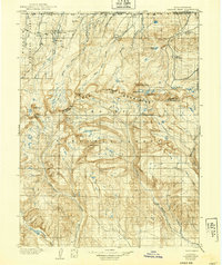
1905 Gilbert Peak
Duchesne County, UT

1906 Gilbert Peak
Duchesne County, UT

1962 Avintaquin Canyon
Duchesne County, UT

1962 Blacktail Mtn
Duchesne County, UT

1962 Buck Knoll
Duchesne County, UT

1962 Dry Mountain
Duchesne County, UT

1962 Farm Creek Peak
Duchesne County, UT

1962 Fruitland
Duchesne County, UT

1962 Hanna
Duchesne County, UT

1962 Rabbit Gulch
Duchesne County, UT

1962 Sams Canyon
Duchesne County, UT

1962 Strawberry Pinnacles
Duchesne County, UT

1962 Tabby Mountain
Duchesne County, UT

1964 Bridgeland
Duchesne County, UT

1964 Duchesne NE
Duchesne County, UT

1964 Duchesne SE
Duchesne County, UT

1964 Duchesne SW
Duchesne County, UT

1964 Myton SE
Duchesne County, UT

1964 Myton SW
Duchesne County, UT

1965 Altonah
Duchesne County, UT

1965 Bollie Lake
Duchesne County, UT

1965 Burnt Mill Spring
Duchesne County, UT

1965 Chepeta Lake
Duchesne County, UT

1965 Fox Lake
Duchesne County, UT

1965 Hancock Cove
Duchesne County, UT

1965 Heller Lake
Duchesne County, UT

1965 Kings Peak
Duchesne County, UT

1965 Mountain Home
Duchesne County, UT

1965 Mount Emmons
Duchesne County, UT

1965 Neola NW
Duchesne County, UT

1965 Pole Creek Cave
Duchesne County, UT

1965 Rasmussen Lakes
Duchesne County, UT

1965 Talmage
Duchesne County, UT

1965 Wilkin Ridge
Duchesne County, UT

1967 Explorer Peak
Duchesne County, UT

1967 Garfield Basin
Duchesne County, UT

1967 Kidney Lake
Duchesne County, UT

1967 Lake Fork Mtn
Duchesne County, UT

1967 Oweep Creek
Duchesne County, UT

1967 Tworoose Pass
Duchesne County, UT

1968 Anthro Mtn
Duchesne County, UT

1968 Anthro Mtn NE
Duchesne County, UT

1968 Cowboy Bench
Duchesne County, UT

1968 Currant Canyon
Duchesne County, UT

1968 Gilsonite Draw
Duchesne County, UT

1968 Jones Hollow
Duchesne County, UT

1968 Lance Canyon
Duchesne County, UT

1968 Pinnacle Canyon
Duchesne County, UT

1968 Wood Canyon
Duchesne County, UT

1969 Gray Head Peak
Duchesne County, UT

1969 Minnie Maud Creek East
Duchesne County, UT

1969 Minnie Maud Creek West
Duchesne County, UT

1972 Grandaddy Lake
Duchesne County, UT

1972 Hayden Peak
Duchesne County, UT

1982 Kings Peak
Duchesne County, UT

1996 Anthro Mountain
Duchesne County, UT

1996 Anthro Mountain NE
Duchesne County, UT

1996 Avintaquin Canyon
Duchesne County, UT

1996 Bollie Lake
Duchesne County, UT

1996 Burnt Mill Spring
Duchesne County, UT

1996 Chepeta Lake
Duchesne County, UT

1996 Currant Canyon
Duchesne County, UT

1996 Dark Canyon
Duchesne County, UT

1996 Dry Mountain
Duchesne County, UT

1996 Explorer Peak
Duchesne County, UT

1996 Farm Creek Peak
Duchesne County, UT

1996 Fox Lake
Duchesne County, UT

1996 Garfield Basin
Duchesne County, UT

1996 Gilsonite Draw
Duchesne County, UT

1996 Grandaddy Lake
Duchesne County, UT

1996 Gray Head Peak
Duchesne County, UT

1996 Hanna
Duchesne County, UT

1996 Hayden Peak
Duchesne County, UT

1996 Heller Lake
Duchesne County, UT

1996 Jones Hollow
Duchesne County, UT

1996 Kidney Lake
Duchesne County, UT

1996 Kings Peak
Duchesne County, UT

1996 Lake Fork Mountain
Duchesne County, UT

1996 Lance Canyon
Duchesne County, UT

1996 Mount Emmons
Duchesne County, UT

1996 Rasmussen Lakes
Duchesne County, UT

1996 Wood Canyon
Duchesne County, UT

2023 Altonah
Duchesne County, UT

2023 Anthro Mountain
Duchesne County, UT

2023 Anthro Mountain NE
Duchesne County, UT

2023 Avintaquin Canyon
Duchesne County, UT

2023 Blacktail Mountain
Duchesne County, UT

2023 Bollie Lake
Duchesne County, UT

2023 Bridgeland
Duchesne County, UT

2023 Buck Knoll
Duchesne County, UT

2023 Burnt Mill Spring
Duchesne County, UT

2023 Chepeta Lake
Duchesne County, UT

2023 Cowboy Bench
Duchesne County, UT

2023 Currant Canyon
Duchesne County, UT

2023 Dark Canyon
Duchesne County, UT

2023 Dry Mountain
Duchesne County, UT

2023 Duchesne NE
Duchesne County, UT

2023 Duchesne SE
Duchesne County, UT

2023 Duchesne SW
Duchesne County, UT

2023 Explorer Peak
Duchesne County, UT

2023 Farm Creek Peak
Duchesne County, UT

2023 Fox Lake
Duchesne County, UT

2023 Fruitland
Duchesne County, UT

2023 Garfield Basin
Duchesne County, UT

2023 Gilsonite Draw
Duchesne County, UT

2023 Grandaddy Lake
Duchesne County, UT

2023 Gray Head Peak
Duchesne County, UT

2023 Hancock Cove
Duchesne County, UT

2023 Hanna
Duchesne County, UT

2023 Hayden Peak
Duchesne County, UT

2023 Heller Lake
Duchesne County, UT

2023 Jones Hollow
Duchesne County, UT

2023 Kidney Lake
Duchesne County, UT

2023 Kings Peak
Duchesne County, UT

2023 Lake Fork Mountain
Duchesne County, UT

2023 Lance Canyon
Duchesne County, UT

2023 Minnie Maud Creek East
Duchesne County, UT

2023 Minnie Maud Creek West
Duchesne County, UT

2023 Mountain Home
Duchesne County, UT

2023 Mount Emmons
Duchesne County, UT

2023 Myton SE
Duchesne County, UT

2023 Myton SW
Duchesne County, UT

2023 Neola NW
Duchesne County, UT

2023 Oweep Creek
Duchesne County, UT

2023 Pinnacle Canyon
Duchesne County, UT

2023 Rabbit Gulch
Duchesne County, UT

2023 Rasmussen Lakes
Duchesne County, UT

2023 Sams Canyon
Duchesne County, UT

2023 Strawberry Pinnacles
Duchesne County, UT

2023 Tabby Mountain
Duchesne County, UT

2023 Talmage
Duchesne County, UT

2023 Tworoose Pass
Duchesne County, UT

2023 Wilkin Ridge
Duchesne County, UT

2023 Wood Canyon
Duchesne County, UT