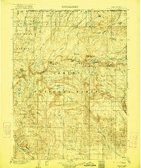
1906 Map of Gilbert Peak
USGS Topo · Published 1921About this map
Gilbert Peak and the surrounding high country of the Uinta Mountains dominate this early twentieth-century topographical record of the Utah-Wyoming border. The landscape is defined by the intricate headwaters of the Uinta River, Henry's Fork, and Smith Fork, which carve through the Ashley National Forest and Wasatch National Forest. This era shows the region as a primary watershed and grazing area, marked by isolated outposts like Smith's Ranch and Edwards Ranch near the northern boundary. Higher elevations reveal a labyrinth of alpine basins containing Lake Atwood, Hoop Lake, and Fish Lake. The mapping captures the geological prominence of the Kings Peaks and Mt Emmons, providing a detailed look at the drainage patterns and timber resources before modern development or road networks penetrated these high-altitude meadows like Gilbert Meadows.
Find a feature on this map
46 named features on this map. Tap any name to fly to it.
Don’t see what you’re looking for? This feature index may not catch every label — zoom into the map to look around manually.
Map Details
Editions of this 1906 Gilbert Peak Map
4 editions found
Other maps of this area

1885 · Ashley
USGS Topo · 1:250,000

1885 · Uinta
USGS Topo · 1:250,000

1901 · Hayden Peak
USGS Topo · 1:125,000

1903 · Hayden Peak
USGS Topo · 1:125,000

1905 · Gilbert Peak
USGS Topo · 1:125,000

1906 · Gilbert Peak
USGS Topo · 1:125,000

1906 · Marsh Peak
USGS Topo · 1:125,000

1908 · Marsh Peak
USGS Topo · 1:125,000

1917 · Vernal
USGS Topo · 1:125,000

1939 · Duchesne
USGS Topo · 1:125,000