
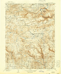
1908 Map of Marsh Peak
USGS Topo · Published 1908About this map
Marsh Peak and the high summits of the Uinta Mountains dominate this early 20th-century survey of the Utah-Wyoming borderlands. The landscape is defined by the dramatic descent from alpine peaks into the deep incisions of Red Canyon and the Green River at Flaming Gorge. A modest high-altitude economy is evident through a network of isolated outposts and timber operations, including Johnsons Mill, Griffins Mill, and Bowles Mill.
Find a feature on this map
55 named features on this map. Tap any name to fly to it.
Don’t see what you’re looking for? This feature index may not catch every label — zoom into the map to look around manually.
Map Details
Editions of this 1908 Marsh Peak Map
2 editions found
Other maps of this area

1885 · Ashley
USGS Topo · 1:250,000

1885 · Uinta
USGS Topo · 1:250,000

1905 · Gilbert Peak
USGS Topo · 1:125,000

1906 · Gilbert Peak
USGS Topo · 1:125,000

1906 · Marsh Peak
USGS Topo · 1:125,000

1907 · Jensen
USGS Topo · 1:125,000

1910 · Jensen
USGS Topo · 1:125,000
1917 · Vernal
USGS Topo · 1:125,000
1939 · Duchesne
USGS Topo · 1:125,000
1950 · Burnt Cabin Gorge
USGS Topo · 1:24,000