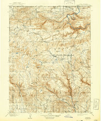
1908 Map of Marsh Peak
USGS Topo · Published 1941About this map
Uinta National Forest dominates the high-altitude landscape of this 1905–1906 survey, where the rugged Uinta Mountains are dissected by the headwaters of the Green River. The presence of several remote resource-extraction sites, including the Dyer Mine and a series of timber operations like Griffins Mill, Johnsons Mill, and Flume Mill, reveals an era of intense mountain industry before the region became primarily recreational. The survey captures early high-country settlements and outposts, notably Manila and Linwood near the Wyoming border, and isolated shelters such as Deadman Cabin and Dodds Cabin. Topographic detail follows the deep incision of Horseshoe Canyon and Red Canyon, illustrating the complex drainage patterns of Ashley Creek and Whiterocks River flowing south from the divide. This map provides a look at the early infrastructure of the Salt Lake Base Line and the Uinta Meridian as surveyors established boundaries across the peaks of Marsh Peak and Leidy Peak.
Find a feature on this map
67 named features on this map. Tap any name to fly to it.
Don’t see what you’re looking for? This feature index may not catch every label — zoom into the map to look around manually.
Map Details
Editions of this 1908 Marsh Peak Map
2 editions found
Other maps of this area

1885 · Ashley
USGS Topo · 1:250,000

1885 · Uinta
USGS Topo · 1:250,000

1905 · Gilbert Peak
USGS Topo · 1:125,000

1906 · Gilbert Peak
USGS Topo · 1:125,000

1906 · Marsh Peak
USGS Topo · 1:125,000

1907 · Jensen
USGS Topo · 1:125,000

1908 · Marsh Peak
USGS Topo · 1:125,000

1910 · Jensen
USGS Topo · 1:125,000

1917 · Vernal
USGS Topo · 1:125,000

1939 · Duchesne
USGS Topo · 1:125,000