Old Maps of Daggett County, Utah
Explore 195 old maps of Daggett County, spanning from 1885 to today. These high-resolution historic maps reveal how streets, neighborhoods, landmarks, and natural features evolved over time — perfect for genealogy, metal detecting, research, and local history exploration.
What you can do with these maps:
- See how Daggett County changed over time: Compare historical maps to modern-day views to trace roads, homesites, rail lines & more.
- View detailed metadata: Each map includes creators, publishers, year, scale, and archive source.
- Overlay maps with satellite & LiDAR: Visualize the past alongside modern tools to explore terrain & human change.
- Trusted historical sources: Maps sourced from the USGS, Library of Congress, and other archives.
- Access maps your way: View online, download high-res files, or order prints for personal or research use.
Start exploring old maps of Daggett County to uncover forgotten places, hidden landmarks, and the deep history beneath your feet.
Daggett County, UT maps
(195)- 1885 Map of Ashley
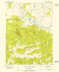
 1885 Ashley1885 Print · USGSThe Uinta Basin in the mid-1880s was a landscape defined by the winding Green River and the high peaks of the eastern Uintas. Researchers can trace early outposts like White Rocks and settlements such as Ashley and Ouray.5 unique versions available
 - 1885 Map of Uinta
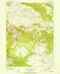
 1885 Uinta1885 Print · USGSThe high wilderness of northern Utah is documented during the early surveying era of the 1880s. Geologists and historians can trace the headwaters of the Duchesne River and locate landmarks like Gilbert Peak and Rhodes Plateau.6 unique versions available
 - 1905 Map of Gilbert Peak, 1953 Print
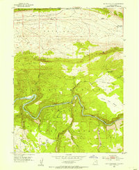
 1905 Gilbert Peak1953 Print · USGSThe High Uintas at the turn of the century show a wilderness of massive peaks and early mountain ranching. Genealogists and researchers can trace the locations of isolated outposts like Smiths Ranch or Edwards Ranch and name specific summits like Mt Emmons.2 unique versions available
 - 1906 Map of Gilbert Peak
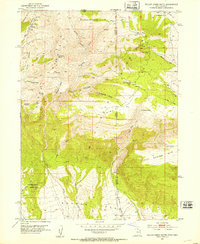
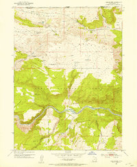
 1906 Gilbert Peak1906 Print · USGSThe high Uinta Mountains are captured in the early 1900s, showing a remote wilderness of glacial lakes and pioneer outposts. Local historians can trace early mountain life through Smiths Ranch, Gilbert Meadows, and Edwards Ranch.4 unique versions available
 - 1906 Map of Marsh Peak
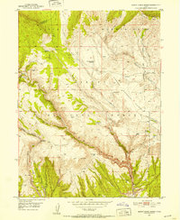
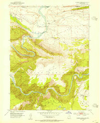
 1906 Marsh Peak1906 Print · USGSThe Uinta Mountains and the winding Green River corridor come alive in this survey from the early 1900s. Genealogists and historians can trace the foundations of high-country industry at Dyer Mine or locate early outposts like Dodds Cabin and Manila.2 unique versions available
 - 1908 Map of Marsh Peak
 1908 Marsh Peak1908 Print · USGSThe high Uinta wilderness along the Utah and Wyoming border is captured here during the first decade of the 1900s. Researchers can trace early industry and remote dwellings such as the Dyer Mine, Johnsons Mill, and Dodds Cabin.2 unique versions available
 - 1950 Map of Burnt Cabin Gorge, 1952 Print
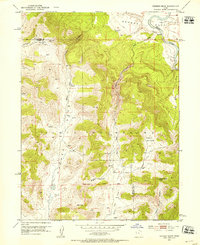
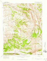
 1950 Burnt Cabin Gorge1952 Print · USGSThe high Uinta backcountry of 1950 shows a working landscape of stock reservoirs and deep canyons. Trace the history of high-country ranching at the Diamond Counting Corral or explore the rugged depths of Burnt Cabin Gorge.2 unique versions available
 - 1950 Map of Dyer Mountain, 1952 Print
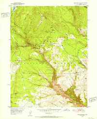 1950 Dyer Mountain1952 Print · USGSUintah County's high-country mining and forest management are captured here during the early fifties. Researchers can locate the historic Bullionville (Site), trace the Government Ditch, and explore the area around the Dyer Mines.3 unique versions available
 - 1952 Map of Warren Draw, 1953 Print
 1952 Warren Draw1953 Print · USGSThe high Uinta Mountains and the winding Green River meet in this early 1950s survey of the Daggett and Uintah county line. Researchers can locate critical water sources and high-altitude crossings like Spitzenberg Spring, Dead Horse Pass, and Felix Pass.2 unique versions available
 - 1952 Map of Willow Creek Butte, 1953 Print
 1952 Willow Creek Butte1953 Print · USGSThe high desert tri-state border country where Utah, Colorado, and Wyoming meet is captured here in the early fifties. Local historians can trace early exploration routes and water sources like Slippery Jim Spr, Whisky Peak, and several Prospect sites.3 unique versions available
 - 1952 Map of Swallow Canyon, 1953 Print
 1952 Swallow Canyon1953 Print · USGSThe Utah-Colorado borderland comes into focus in the early fifties, where the Green River enters the narrow Swallow Canyon. Researchers can trace the rugged terrain of the Uinta Mountains and find local landmarks like Marshall and Crouse Creek.5 unique versions available
 - 1952 Map of Clay Basin, 1954 Print
 1952 Clay Basin1954 Print · USGSDaggett County and the Wyoming border are captured here in the early fifties, showing the region during a period of active natural resource exploration. Researchers can locate Clay Basin Camp, trace the Green River through Browns Park, and identify isolated landmarks like Two Horse Butte and Band Box Butte.4 unique versions available
 - 1952 Map of Dutch John Mtn, 1954 Print
 1952 Dutch John Mtn1954 Print · USGSThe Green River backcountry on the Utah-Wyoming border is captured here in the early fifties, just before the Flaming Gorge dam changed the canyon floor forever. Researchers can trace the original river course past Ashley Falls and locate remote sites like the Dutch John Spring Ranger Station and Greendale.2 unique versions available
 - 1952 Map of Goslin Mtn, 1954 Print
 1952 Goslin Mtn1954 Print · USGSThe high desert border of Utah and Wyoming is captured here in the early fifties, before the landscape was transformed by modern dam projects. Researchers can trace historic landmarks like Dutch John Mtn, the remote Lowline Trail, and numerous named water sources like Edith Aspden Park Springs.3 unique versions available
 - 1952 Map of Flaming Gorge, 1954 Print
 1952 Flaming Gorge1954 Print · USGSThe Green River flows through its natural canyons in the early fifties, just before the landscape was transformed by dam construction. Trace historic land use through Williams Ranch, the Hideout Trail, and river crossings like the Footbridge at Flaming Gorge.2 unique versions available
 - 1954 Map of Salt Lake City, 1964 Print
 1954 Salt Lake City1964 Print · USGSThe Wasatch Front and Uinta Mountains are captured here in the mid-fifties, showing the industrial heart of Utah and its high mountain wilderness. Researchers can locate vanished infrastructure and landmarks like the Geneva Steel Plant, Bingham Canyon Mine, and the Utah State Prison.4 unique versions available
 - 1954 Map of Vernal, 1966 Print
 1954 Vernal1966 Print · USGSThe Green River basin and Uinta Mountains come alive in this mid-century survey of northeastern Utah and northwestern Colorado. Genealogists and researchers can trace the development of remote outposts like Little Bonanza, Artesia, and Dutch John alongside the expanding Flaming Gorge Reservoir.4 unique versions available
 - 1954 Map of Rock Springs, 1969 Print
 1954 Rock Springs1969 Print · USGSSouthern Wyoming at the peak of the mid-century energy boom is defined by the vital rail corridor and the high desert of the Red Desert Basin. Trace the development of mining towns like Superior and Reliance alongside the Union Pacific RR and historical landmarks like Pilot Butte.2 unique versions available
 - 1957 Map of Currant Creek Ranch, 1959 Print
 1957 Currant Creek Ranch1959 Print · USGSThe Wyoming-Utah borderlands are captured here in the late fifties, showing a landscape defined by high ridges and remote ranching outposts. Researchers can trace historic water rights and early trails through Currant Creek Ranch, Minnies Gap, and Sugarloaf Reservoir.2 unique versions available
 - 1958 Map of Vernal
 1958 Vernal1958 Print · USGSThe Uinta Basin at the end of the fifties reveals a landscape shaped by massive river systems and burgeoning energy interests. Researchers can trace the layout of Uintah and Ouray Indian Reservation lands and industrial sites like the Gilsonite coking plant and Bonanza.
 - 1958 Map of Salt Lake City
 1958 Salt Lake City1958 Print · USGSThe Wasatch Front and Uinta Basin are captured during a period of significant post-war growth and industrial development. Researchers can trace the mid-century rail lines of the Bamberger RR and locate sites like the Kiegley Limestone Quarry and Camp Williams Military Reservation.
 - 1958 Map of Rock Springs
 1958 Rock Springs1958 Print · USGSThe high desert of Sweetwater County comes into focus during the mid-1950s, centered on the rail-and-road corridor through Rock Springs. Genealogists and historians can trace family landholdings and infrastructure at Barnhart Ranch, Little America, and the Union Pacific line.2 unique versions available
 - 1960 Map of Salt Lake City
 1960 Salt Lake City1960 Print · USGSThe Wasatch Front and High Uintas are captured mid-century as the Salt Lake Valley underwent significant postwar expansion. Genealogists and historians can trace rail lines like the Union Pacific and locate established landmarks such as Fort Douglas, Camp Williams, and the Bingham Canyon Mine.
 - 1960 Map of Vernal
 1960 Vernal1960 Print · USGSNortheastern Utah was a rugged frontier of mineral extraction and federal conservation in the mid-twentieth century. Genealogists and historians can trace the growth of Vernal, locate Gilsonite mining operations near Bonanza, and explore the 1950s boundaries of Dinosaur National Monument.
 - 1962 Map of Rock Springs
 1962 Rock Springs1962 Print · USGSThe high desert of Sweetwater County in the early 1960s reveals a rugged ranching and energy landscape centered on Rock Springs. Genealogists can trace family holdings like the Erikson-Kent Ranch and Barnhart Ranch alongside the Union Pacific line.
Showing maps 1-25 of 195
Top cities of Daggett County
Frequently asked questions
- What are the different types of historical maps available for Daggett County?
- What is the oldest map of Daggett County?
- Where can I purchase historical maps of Daggett County for my home or office?
- Where can I download high-res historical maps of Daggett County?
- Are there historical topographic maps available for Daggett County?
- Is there historical aerial imagery available for Daggett County?
- Where are historical maps of Daggett County sourced from?