1960s Maps of Daggett County, Utah
Explore 21 historic maps of Daggett County from the 1960s. These maps offer a rare glimpse into what life looked like during the 1960s — showing old roads, neighborhoods, homes, and landmarks that have changed or disappeared over time.
Whether you're researching your family's past, planning a metal detecting trip, or studying how Daggett County's landscape evolved across the 1960s, these high-resolution maps are a powerful tool for exploring the history of this region.
- Focus on a specific era: All maps on this page are from the 1960s, giving you a focused view of this time period.
- See what’s changed: Compare century-old streets, trails, and buildings to today's modern landscape using overlays and satellite layers.
- Research with precision: Use these maps for genealogy, historical research, land use analysis, or educational projects.
- View, download, or print: Maps are fully viewable online in high resolution, and can be downloaded or printed for your own records.
Start exploring Daggett County's history through authentic maps from the 1960s. This is your window into the past.
Daggett County, UT maps
(21)- 1960 Map of Salt Lake City
 1960 Salt Lake City1960 Print · USGSThe Wasatch Front and High Uintas are captured mid-century as the Salt Lake Valley underwent significant postwar expansion. Genealogists and historians can trace rail lines like the Union Pacific and locate established landmarks such as Fort Douglas, Camp Williams, and the Bingham Canyon Mine.
 - 1960 Map of Vernal
 1960 Vernal1960 Print · USGSNortheastern Utah was a rugged frontier of mineral extraction and federal conservation in the mid-twentieth century. Genealogists and historians can trace the growth of Vernal, locate Gilsonite mining operations near Bonanza, and explore the 1950s boundaries of Dinosaur National Monument.
 - 1962 Map of Rock Springs
 1962 Rock Springs1962 Print · USGSThe high desert of Sweetwater County in the early 1960s reveals a rugged ranching and energy landscape centered on Rock Springs. Genealogists can trace family holdings like the Erikson-Kent Ranch and Barnhart Ranch alongside the Union Pacific line.
 - 1963 Map of Whiterocks Lake, 1964 Print
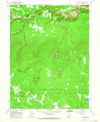
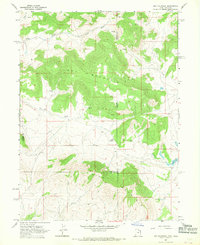
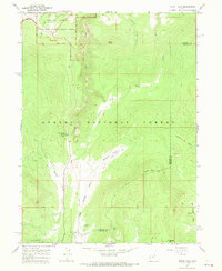
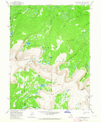 1963 Whiterocks Lake1964 Print · USGSThe high Uinta basins of Daggett and Uintah counties are shown here in the early sixties, highlighting remote water systems and historical borders. Researchers can trace the Old Indian Treaty Boundary and locate early sites like Spirit Lake Campground or Whiterocks Lake.3 unique versions available
 - 1963 Map of Manila, 1964 Print
 1963 Manila1964 Print · USGSThe Lucerne Valley and the rising slopes of the Uinta Mountains are captured here in the early 1960s, just as the regional landscape was being reshaped. You can trace early recreation sites like Moenkopi Campground alongside vital irrigation works such as Peoples Canal and the Canal near Manila.2 unique versions available
 - 1963 Map of Leidy Peak, 1964 Print
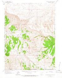
 1963 Leidy Peak1964 Print · USGSThe high Uinta Mountains of northern Utah are mapped here in the early 1960s, showing the intersection of Daggett and Uintah counties. Researchers can trace high-altitude water sources and early paths like the Uinta Highline Trail, Long Park Res, and Icy Hill Dugway.2 unique versions available
 - 1963 Map of East Park Reservoir, 1964 Print
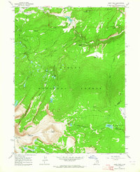
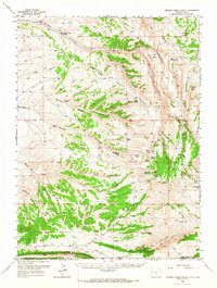
 1963 East Park Reservoir1964 Print · USGSThe Uinta Mountains high country comes into focus in the early sixties as a hub for water storage and alpine recreation. Trace the remote network of the High Line (Jeep) Trail and locate seasonal landmarks like Dyer Park or the Greens Lakes Campground.3 unique versions available
 - 1963 Map of Elk Park, 1964 Print
 1963 Elk Park1964 Print · USGSThe high Uintas in the early sixties reveal a landscape of remote mountain parks and early forest management. Local historians can trace the Old Military Reservation Boundary and find secluded spots like Pat Carroll Park and the Trout Creek Guard Station.3 unique versions available
 - 1963 Map of Phil Pico Mtn, 1965 Print
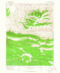 1963 Phil Pico Mtn1965 Print · USGSThe high ridges of the Uinta Mountains come into focus in the early sixties as they straddle the Utah-Wyoming border. Historians and researchers can trace high-country water systems like the Sheep Creek Canal and find remote landmarks such as Anson Cabin and Hickerson Park.3 unique versions available
 - 1963 Map of Jessen Butte, 1965 Print
 1963 Jessen Butte1965 Print · USGSThe high basins and irrigation networks of the Utah-Wyoming border come into focus during the early sixties. Researchers can trace the path of the Lucerne Valley Canal or locate local landmarks like Sheep Creek Lake and Jessen Butte.2 unique versions available
 - 1963 Map of Richards Gap, 1966 Print
 1963 Richards Gap1966 Print · USGSThe high desert borderlands between Wyoming and Utah are captured in the early 1960s, showing a remote landscape of canyons and springs. Trace the historic pathways through Richards Gap and locate old water sources like Bad Steer Spring and Ely Spring.3 unique versions available
 - 1963 Map of Red Creek Ranch, 1966 Print
 1963 Red Creek Ranch1966 Print · USGSThe tri-state borders of Wyoming, Utah, and Colorado come together in this early 1960s survey of the high desert. Genealogists and local historians can locate remote family outposts like Red Creek Ranch, Meadow Gulch Ranch, and Petes Place among the Red Creek Badlands.2 unique versions available
 - 1965 Map of Chepeta Lake, 1967 Print
 1965 Chepeta Lake1967 Print · USGSHigh in the Uinta Mountains during the mid-sixties, this area shows a wilderness of glacial basins and early forest service infrastructure. You can trace the Old Indian Treaty Boundary and locate remote campsites like the Spirit Lake Lodge Campground near Chepeta Lake.
 - 1966 Map of Dutch John, 1967 Print
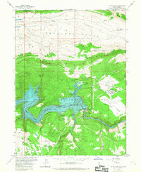 1966 Dutch John1967 Print · USGSThe high desert of Daggett County undergoes a dramatic transformation in the mid-1960s as the newly created reservoir fills the canyon. Researchers can trace the development of the Dutch John community and key infrastructure like the Flaming Gorge Dam and Dutch John Airport.
 - 1966 Map of Currant Creek Ranch, 1967 Print
 1966 Currant Creek Ranch1967 Print · USGSThe high-country borderlands of Sweetwater County and northern Utah are detailed here in the mid-sixties, showing a landscape of isolated ranching outposts and remote mountain passes. Researchers can locate family landmarks like Greenhough Place and Currant Creek Ranch, or trace trails through Minnies Gap and The Narrows.
 - 1966 Map of Flaming Gorge, 1967 Print
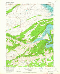
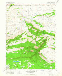
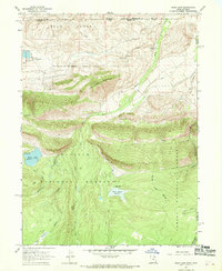
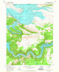 1966 Flaming Gorge1967 Print · USGSThe Utah-Wyoming borderlands were transforming into a recreation hub in the mid-sixties as the reservoir filled behind the dam. Trace the emergence of the Lucerne Valley Development alongside old-line features like Trail Creek Ranch and Greendale.2 unique versions available
 - 1967 Map of Hoy Mountain, 1969 Print
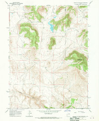
 1967 Hoy Mountain1969 Print · USGSThe high country of the Utah-Colorado border is captured here during the late 1960s, showing a landscape defined by water and remote peaks. Researchers can locate isolated landmarks like Offield Reservoir, the Gaging Station, and the primitive Jeep Trail crossing Hoy Mountain.2 unique versions available
 - 1967 Map of Hoop Lake, 1969 Print
 1967 Hoop Lake1969 Print · USGSThe high Uinta wilderness along the Utah-Wyoming border is captured here in the late sixties as a land of forest management and early recreation. Outdoor historians can trace old Pack Trails and Jeep Trails connecting Hoop Lake to Bull Park and Kabell Meadows.
 - 1967 Map of Jackson Draw, 1970 Print
 1967 Jackson Draw1970 Print · USGSUintah County high country in the late sixties reveals a landscape of high-elevation reservoirs and rugged drainage draws. Trace the infrastructure of the Ashley National Forest and water sources like the Matt Warner Reservoir and Pot Creek.2 unique versions available
 - 1967 Map of Crouse Reservoir, 1970 Print
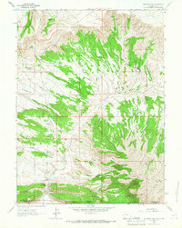
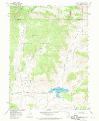
 1967 Crouse Reservoir1970 Print · USGSThe high plateau of northeastern Utah in the late sixties shows a landscape of water management and remote boundary lines. Researchers can trace the hydraulic network of Crouse Reservoir, from the Ditch systems to landmarks like Hoy Mtn and Diamond Gulch.2 unique versions available
 - 1967 Map of Mount Lena, 1970 Print
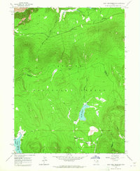
 1967 Mount Lena1970 Print · USGSHigh-country Utah at the height of the 1960s recreation boom reveals a landscape of mountain peaks and new national forest amenities. Trace the development of the Grizzly Ridge Winter Sports Area or locate historic seasonal outposts like Stringham Cabin and Greendale.2 unique versions available
End of results
Showing maps 1-21 of 21
Top cities of Daggett County
Frequently asked questions
- What are the different types of historical maps available for Daggett County?
- What is the oldest map of Daggett County?
- Where can I purchase historical maps of Daggett County for my home or office?
- Where can I download high-res historical maps of Daggett County?
- Are there historical topographic maps available for Daggett County?
- Is there historical aerial imagery available for Daggett County?
- Where are historical maps of Daggett County sourced from?