1990s Maps of Daggett County, Utah
Explore 18 historic maps of Daggett County from the 1990s. These maps offer a rare glimpse into what life looked like during the 1990s — showing old roads, neighborhoods, homes, and landmarks that have changed or disappeared over time.
Whether you're researching your family's past, planning a metal detecting trip, or studying how Daggett County's landscape evolved across the 1990s, these high-resolution maps are a powerful tool for exploring the history of this region.
- Focus on a specific era: All maps on this page are from the 1990s, giving you a focused view of this time period.
- See what’s changed: Compare century-old streets, trails, and buildings to today's modern landscape using overlays and satellite layers.
- Research with precision: Use these maps for genealogy, historical research, land use analysis, or educational projects.
- View, download, or print: Maps are fully viewable online in high resolution, and can be downloaded or printed for your own records.
Start exploring Daggett County's history through authentic maps from the 1990s. This is your window into the past.
Daggett County, UT maps
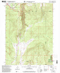
(18)- 1990 Map of Whiterocks Lake, 1995 Print
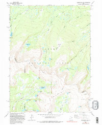 1990 Whiterocks Lake1995 Print · USGSThe high Uinta Mountains are captured here in the late twentieth century, showing a landscape defined by the Old Indian Treaty Boundary and the Ashley National Forest. Researchers can trace old survey lines like the Uintah Special Meridian and find remote landmarks such as Whiterocks Lake and Mount Untermann.
 - 1996 Map of Chepeta Lake, 1999 Print
 1996 Chepeta Lake1999 Print · USGSThe high basins of the Uintas are captured here during the late twentieth century, showing where three northern Utah counties converge. Hikers and researchers can trace remote alpine routes through North Pole Pass to landmarks like Spirit Lake Lodge and Chepeta.
 - 1996 Map of Flaming George, 1999 Print
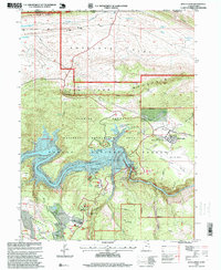
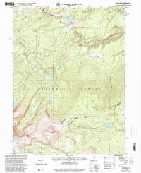
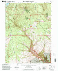
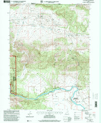
 1996 Flaming George1999 Print · USGSThe high-desert country on the Utah-Wyoming border is captured here in the mid-1990s as the Green River flows into deep canyons. Researchers can locate recreation landmarks like Lucerne Valley Marina alongside older sites such as Trail Creek Ranch and Greendale.
 - 1996 Map of Dutch John, 1999 Print
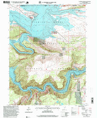
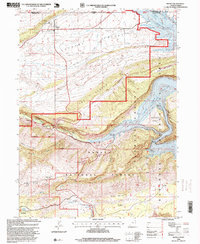
 1996 Dutch John1999 Print · USGSThe Flaming Gorge area in the mid-1990s reflects a landscape defined by massive federal water projects and recreational development. You can trace the local infrastructure from the Flaming Gorge Dam to historic sites like the Sweet Ranch National Historic Site and the Jack Robinson Historic Cabin.
 - 1996 Map of Whiterocks Lake, 1999 Print
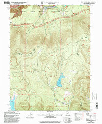
 1996 Whiterocks Lake1999 Print · USGSThe High Uintas wilderness appears in detail during the late nineties, showcasing the complex glacial hydrology at the junction of three Utah counties. Trace remote alpine landmarks like Chepeta, the Sheep Creek Canal, and the high waters of Whiterocks Lake.
 - 1996 Map of East Park Reservoir, 1999 Print
 1996 East Park Reservoir1999 Print · USGSThe high Uinta Mountains of northeastern Utah are captured in the late nineties, showing a landscape defined by water storage and forest trails. Researchers can trace the path of the Uinta Highline Trail or locate remote landmarks like the Spring House and Eagle Creek Bridge.
 - 1996 Map of Burnt Cabin Gorge, 1999 Print
 1996 Burnt Cabin Gorge1999 Print · USGSThe Uinta Mountains high country comes to life in the late twentieth century, showing the rugged transition from the plateau to the gorge. Researchers can trace historic water rights and landmarks like Hole-in-The-Wall, Barker Spring, and Burnt Cabin Gorge.
 - 1996 Map of Manila, 1999 Print
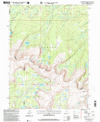
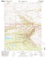
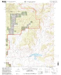
 1996 Manila1999 Print · USGSNear the Wyoming border in the 1990s, the landscape around Manila reveals a rugged transition from high desert valleys to the deep canyons of the Green River. Researchers can trace recreational development along Flaming Gorge Reservoir or locate the Cem and Summit Springs Guard Station.
 - 1996 Map of Leidy Peak, 2000 Print
 1996 Leidy Peak2000 Print · USGSThe high Uinta Mountains and the historic Carter Military Trail are captured here in the mid-1990s. Researchers can trace high-altitude water systems like the Beaver Canal and historic landmarks including the Fire Lookout Tower.
 - 1996 Map of Dyer Mountain, 2000 Print
 1996 Dyer Mountain2000 Print · USGSDyer Mountain and the high plateaus of Uintah County are captured here in the mid-1990s as a landscape of timber and mountain mining. Trace the historical Military Trail and locate remote mining operations at Dyer Mines and the overlooks of Big Brush Gorge.
 - 1996 Map of Jessen Butte, 2000 Print
 1996 Jessen Butte2000 Print · USGSDaggett County and the Wyoming borderlands are captured here in the late nineties as a landscape of forest management and early military history. You can trace the historic Carter Military Trail or locate remote landmarks like Dowds Grave and Palisades Memorial Park.
 - 1996 Map of Hoop Lake, 2000 Print
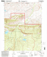 1996 Hoop Lake2000 Print · USGSHigh-altitude borderlands in the Uintas appear here in the mid-nineties as the wilderness and forest boundaries meet. Researchers can trace remote resource infrastructure like the Landing Strip at Gregory Basin and the spillway at Hoop Lake.
 - 1996 Map of Goslin Mountain, 2000 Print
 1996 Goslin Mountain2000 Print · USGSThe Utah-Wyoming borderlands at the end of the century reveal a rugged landscape managed for recreation and resource protection. Outdoorsmen and historians can trace the course of the Green River past numerous backcountry sites like Jackson Camp and Big Pine Camp.
 - 1996 Map of Jackson Draw, 2000 Print
 1996 Jackson Draw2000 Print · USGSThe high country of the Uinta Basin in the mid-1990s is captured here, detailing a landscape defined by forest management and water resources. Researchers can trace the drainage of Jackson Draw or locate remote landmarks like the Landing Strip and Matt Warner Reservoir.
 - 1996 Map of Elk Park, 2000 Print
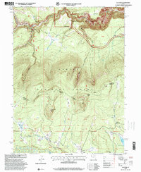 1996 Elk Park2000 Print · USGSHigh Uinta meadows and deep canyons define this Daggett County landscape in the mid-1990s. Trace old routes across Carter Creek Bridge or explore family-named landmarks like Pat Carroll Park and the high ridges of Trout Creek Peak.
 - 1996 Map of Clay Basin, 2000 Print
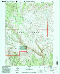
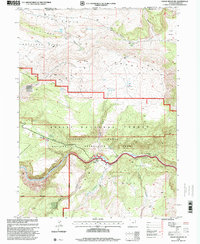
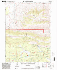
 1996 Clay Basin2000 Print · USGSDaggett County, Utah, and the Wyoming borderlands are documented here in the late twentieth century as a hub for both energy and river recreation. Trace the industrial Gas Wells near Clay Basin Camp or remote riverside sites like Red Creek Ranch.
 - 1996 Map of Phil Pico Mountain, 2000 Print
 1996 Phil Pico Mountain2000 Print · USGSThe high alpine border between Utah and Wyoming comes into focus in the mid-1990s, showcasing the intersection of historical transit and mountain hydrology. Researchers can trace the Carter Military Trail or locate the Lodgepole Canal Bridge and Hickerson Park.
 - 1996 Map of Mount Lena, 2000 Print
 1996 Mount Lena2000 Print · USGSThe high Uinta backcountry on the Daggett and Uintah county line is captured here in the mid-nineties as a hub for wilderness recreation. Local historians can trace seasonal dwellings and remote landmarks like the Deer Lodge Summer Home Area, Stringham Cabin, and the Uinta Highline Trail.
End of results
Showing maps 1-18 of 18
Top cities of Daggett County
Frequently asked questions
- What are the different types of historical maps available for Daggett County?
- What is the oldest map of Daggett County?
- Where can I purchase historical maps of Daggett County for my home or office?
- Where can I download high-res historical maps of Daggett County?
- Are there historical topographic maps available for Daggett County?
- Is there historical aerial imagery available for Daggett County?
- Where are historical maps of Daggett County sourced from?