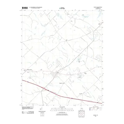
2011 Map of Dudley
USGS Topo · Published 2011About this map
The town of Dudley anchors this Central Georgia landscape, where a network of rural routes and waterway branches defines the settlement pattern in the early 21st century. The map provides a detailed view of family-named landmarks and rural intersections, including Thomas Cross Roads and the rail-oriented crossings of Haskins Crossing and Whipples Crossing. For those researching local genealogy, the area is notably dotted with small family and community burial grounds such as Gilbert Cemetery, Ussery Cemetery, and Poplar Springs Cemetery.
Find a feature on this map
61 named features on this map. Tap any name to fly to it.
Don’t see what you’re looking for? This feature index may not catch every label — zoom into the map to look around manually.
Map Details
Editions of this 2011 Dudley Map
This is the sole edition of this map. No revisions or reprints were ever made.
Other maps of this area

1957 · Macon
USGS Topo · 1:250,000

1958 · Macon
USGS Topo · 1:250,000

1964 · Macon
USGS Topo · 1:250,000

1974 · Chester
USGS Topo · 1:24,000

1974 · Cow Hell Swamp
USGS Topo · 1:24,000

1974 · Danville East
USGS Topo · 1:24,000

1974 · Rentz
USGS Topo · 1:24,000

1974 · Dudley
USGS Topo · 1:24,000
1974 · Nicklesville
USGS Topo · 1:24,000
1974 · Stuckey Boone Lake
USGS Topo · 1:24,000