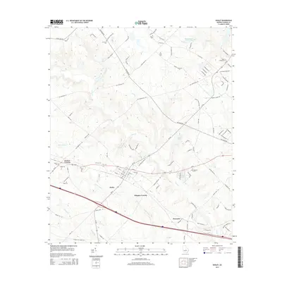
2014 Map of Dudley
USGS Topo · Published 2014About this map
The town of Dudley anchors this 2014 topographic survey of western Laurens County, Georgia, serving as a hub for local road networks like Old Macon Rd and Blackshear Ferry Rd W. The landscape is a network of small agricultural drainages, including Turkey Cr and Little Rocky Cr, which feed into local landmarks such as McLees Lake and Lord Lake. Small settlements and crossings define the community's history, with Haskins Crossing and Whipples Crossing marking key junctions. Genealogists will find a wealth of local burial sites, from family plots like Heath Cem and Pope Cem to larger community grounds such as Oak Grove Cem and Poplar Springs Cem. The terrain is notably marked by Hatchee Ridge in the south, while modern transit corridors like US-80 and I-16 cut through the rural landscape, illustrating the evolution of travel in middle Georgia.
Find a feature on this map
103 named features on this map. Tap any name to fly to it.
Don’t see what you’re looking for? This feature index may not catch every label — zoom into the map to look around manually.
Map Details
Editions of this 2014 Dudley Map
This is the sole edition of this map. No revisions or reprints were ever made.
Other maps of this area

1957 · Macon
USGS Topo · 1:250,000

1958 · Macon
USGS Topo · 1:250,000

1964 · Macon
USGS Topo · 1:250,000

1974 · Chester
USGS Topo · 1:24,000

1974 · Cow Hell Swamp
USGS Topo · 1:24,000

1974 · Danville East
USGS Topo · 1:24,000

1974 · Rentz
USGS Topo · 1:24,000

1974 · Dudley
USGS Topo · 1:24,000
1974 · Nicklesville
USGS Topo · 1:24,000
1974 · Stuckey Boone Lake
USGS Topo · 1:24,000