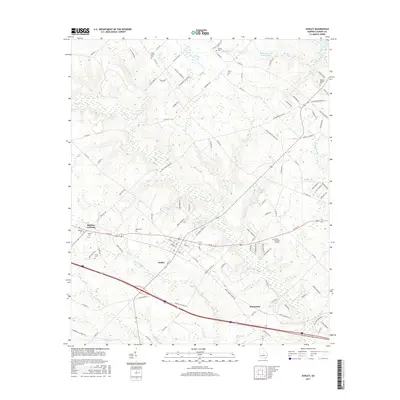
2017 Map of Dudley
USGS Topo · Published 2017About this map
The town of Dudley anchors this central Georgia landscape, where agricultural land meets the drainage basins of Turkey Creek and Little Rocky Creek. The town's layout is closely tied to its transit corridor, while the surrounding countryside is dotted with legacy family sites and rural landmarks. Local history is deeply etched into the terrain through several small burial grounds such as Oak Grove Cemetery, Haskins Cemetery, and Poplar Springs Cemetery. These sites, along with the larger Dublin Memorial Gardens, offer significant points of interest for genealogical research in Laurens County. The hydrology of the area is defined by numerous smaller water bodies and branches, including McHees Lake, Lord Lake, and Collins Branch, which carve through the territory between established routes like Old Hawkinsville Road and Co RD 19.
Find a feature on this map
107 named features on this map. Tap any name to fly to it.
Don’t see what you’re looking for? This feature index may not catch every label — zoom into the map to look around manually.
Map Details
Editions of this 2017 Dudley Map
This is the sole edition of this map. No revisions or reprints were ever made.
Other maps of this area

1957 · Macon
USGS Topo · 1:250,000

1958 · Macon
USGS Topo · 1:250,000

1964 · Macon
USGS Topo · 1:250,000

1974 · Chester
USGS Topo · 1:24,000

1974 · Cow Hell Swamp
USGS Topo · 1:24,000

1974 · Danville East
USGS Topo · 1:24,000

1974 · Rentz
USGS Topo · 1:24,000

1974 · Dudley
USGS Topo · 1:24,000
1974 · Nicklesville
USGS Topo · 1:24,000
1974 · Stuckey Boone Lake
USGS Topo · 1:24,000