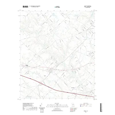
2020 Map of Dudley
USGS Topo · Published 2020About this map
The town of Dudley anchors this Laurens County landscape, where the street grid of 1st St and Main St meets the transit corridors of Interstate 16 and Co Rd 19. The geography is defined by a dense network of family-named cemeteries and watercourses, reflecting generations of rural settlement. To the northwest, Haskins Crossing sits near the Haskins Cem and Heath Cem, while the eastern portion of the map is dominated by the Dublin Memorial Gardens and the waters of Lord Lake. Drainage patterns are intricate, with Little Rocky Cr and Horse Br carving through the terrain towards the southeast. In the lower quadrant, the community of Shewmake appears at the intersection of several county roads, serving as a secondary local hub amidst the agricultural tracts and timberlands of central Georgia.
Find a feature on this map
109 named features on this map. Tap any name to fly to it.
Don’t see what you’re looking for? This feature index may not catch every label — zoom into the map to look around manually.
Map Details
Editions of this 2020 Dudley Map
This is the sole edition of this map. No revisions or reprints were ever made.
Other maps of this area

1957 · Macon
USGS Topo · 1:250,000

1958 · Macon
USGS Topo · 1:250,000

1964 · Macon
USGS Topo · 1:250,000

1974 · Chester
USGS Topo · 1:24,000

1974 · Cow Hell Swamp
USGS Topo · 1:24,000

1974 · Danville East
USGS Topo · 1:24,000

1974 · Rentz
USGS Topo · 1:24,000

1974 · Dudley
USGS Topo · 1:24,000
1974 · Nicklesville
USGS Topo · 1:24,000
1974 · Stuckey Boone Lake
USGS Topo · 1:24,000