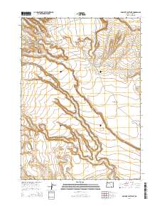
2014 Map of Duhaime Flat West
USGS Topo · Published 2014About this map
Duhaime Flat and its surrounding high-desert terrain dominate this 2014 survey of Harney County, Oregon. The landscape is defined by its seasonal and hidden water sources, which were historically vital for grazing and settlement in this arid region. Significant features include Buckhorn Spring and Little Mud Spring, along with the Mud Spring Reservoir, indicating the careful management of local hydrology. The area is dissected by prominent natural drainages like Augustine Canyon and Buckhorn Canyon, which carve through the plateau. This map reveals a world of wide open spaces and traditional land divisions, where names like Tucke Flat suggest the area's legacy of ranching or early homesteading.
Find a feature on this map
11 named features on this map. Tap any name to fly to it.
Don’t see what you’re looking for? This feature index may not catch every label — zoom into the map to look around manually.
Map Details
Editions of this 2014 Duhaime Flat West Map
This is the sole edition of this map. No revisions or reprints were ever made.
Other maps of this area

1955 · Adel
USGS Topo · 1:250,000

1957 · Adel
USGS Topo · 1:250,000

1958 · Adel
USGS Topo · 1:250,000

1962 · Adel
USGS Topo · 1:250,000

1971 · Duhaime Flat East
USGS Topo · 1:24,000

1971 · Clover Swale
USGS Topo · 1:24,000

1971 · Orejana Canyon
USGS Topo · 1:24,000
1971 · Sixmile Draw
USGS Topo · 1:24,000
1971 · Duhaime Flat West
USGS Topo · 1:24,000
1971 · Keg Sprs Valley West
USGS Topo · 1:24,000