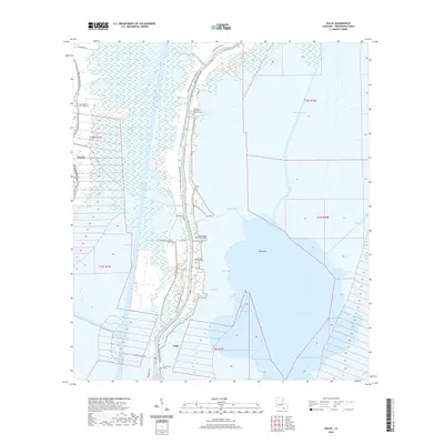
2020 Map of Dulac
USGS Topo · Published 2020About this map
Bayou Grand Caillou and the massive Houma Navigation Canal dominate this wetland landscape, illustrating the critical water-management and navigation infrastructure of modern coastal Louisiana. The settlement of Dulac serves as a hub for the surrounding marshlands, with residential development tightly clustered along narrow corridors like Shrimpers Row and Grand Caillou Rd. The map is particularly notable for its density of family and community burial grounds, including the Célestin Garden-of Memory Cem, Saint Michael Saint Luke Cem, and Holy Family Cem Number 1. These sites, along with others like the Grand Caillou Baptist Cem, provide vital genealogical anchors in a region where the land itself is increasingly defined by water bodies such as Lake Boudreaux and Lake Gero. The transition from established settlements like Theriot to the open expanse of Hog Point reflects the persistent human presence within the Terrebonne Parish wetlands.
Find a feature on this map
36 named features on this map. Tap any name to fly to it.
Don’t see what you’re looking for? This feature index may not catch every label — zoom into the map to look around manually.
Map Details
Editions of this 2020 Dulac Map
This is the sole edition of this map. No revisions or reprints were ever made.
Other maps of this area

1892 · Gibson
USGS Topo · 1:62,500

1892 · Houma
USGS Topo · 1:62,500

1894 · Bayou De Large
USGS Topo · 1:62,500

1894 · Dulac
USGS Topo · 1:62,500

1897 · Gibson
USGS Topo · 1:62,500

1932 · Houma SE
USGS Topo · 1:31,680

1932 · Houma SW
USGS Topo · 1:31,680

1935 · Theriot
USGS Topo · 1:31,680

1935 · Bourbeux
USGS Topo · 1:31,680

1935 · Montegut
USGS Topo · 1:31,680