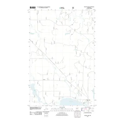
2011 Map of Dunbar Lake
USGS Topo · Published 2011About this map
Popple River meanders through the heart of this Northwoods landscape, connecting a network of waterways that defined early settlement patterns in Itasca County. The village of Squaw Lake serves as a local hub near the southern edge of the map, anchored by the Squaw Lake Post Office and the nearby North Round Lake Cemetery. This survey highlights the region's complex hydrology, from the broad expanse of Round Lake to smaller bodies like Hamrey Lake and Natures Lake. The small settlement of Dunbar stands near the confluence of Dunbar Creek and the Dunbar River, a testament to the era's reliance on water and rail access. A dense grid of forest roads, including Forest Rd 2229, cuts through the timberland, indicating the ongoing importance of the forestry industry and local accessibility in this lake-rich territory.
Find a feature on this map
75 named features on this map. Tap any name to fly to it.
Don’t see what you’re looking for? This feature index may not catch every label — zoom into the map to look around manually.
Map Details
Editions of this 2011 Dunbar Lake Map
This is the sole edition of this map. No revisions or reprints were ever made.
Other maps of this area

1919 · Rosy
USGS Topo · 1:62,500

1919 · Gemmell
USGS Topo · 1:62,500

1919 · Max
USGS Topo · 1:62,500

1919 · Bridgie
USGS Topo · 1:62,500

1924 · Bridgie
USGS Topo · 1:62,500

1954 · Bemidji
USGS Topo · 1:250,000

1957 · Bemidji
USGS Topo · 1:250,000

1958 · Bemidji
USGS Topo · 1:250,000

1971 · Squaw Lake
USGS Topo · 1:24,000

1971 · Dixon Lake
USGS Topo · 1:24,000