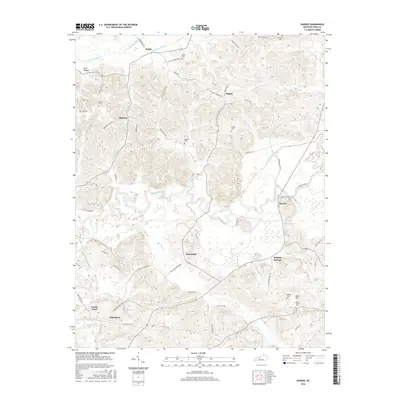
2016 Map of Dundee
USGS Topo · Published 2016About this map
The Rough River winds through the heart of this Ohio County landscape, creating a serpentine boundary for the agricultural and residential communities of Dundee and Sunnydale. The area is characterized by its numerous family-named landmarks and historical burial grounds, such as Mount Vernon Cem and Midkiff Cem, which speak to the deep genealogical roots of the region. Transportation and connectivity rely on a network of named country roads and bridges, including the crossing at Combs Ford and the path of Morgantown Rd.
Find a feature on this map
66 named features on this map. Tap any name to fly to it.
Don’t see what you’re looking for? This feature index may not catch every label — zoom into the map to look around manually.
Map Details
Editions of this 2016 Dundee Map
This is the sole edition of this map. No revisions or reprints were ever made.
Other maps of this area

1907 · Whitesville
USGS Topo · 1:62,500

1909 · Whitesville
USGS Topo · 1:62,500

1909 · Hartford
USGS Topo · 1:62,500

1925 · Spring Lick
USGS Topo · 1:62,500

1932 · Fordsville
USGS Topo · 1:62,500

1953 · Philpot
USGS Topo · 1:24,000

1953 · Dundee
USGS Topo · 1:24,000

1953 · Whitesville
USGS Topo · 1:24,000

1953 · Pleasant Ridge
USGS Topo · 1:24,000
1953 · Fordsville
USGS Topo · 1:24,000