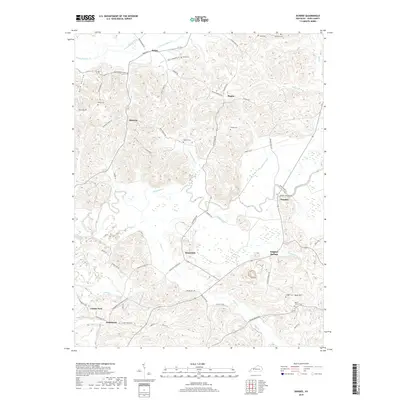
2019 Map of Dundee
USGS Topo · Published 2019About this map
The Rough River meanders through this portion of Ohio County, carving a valley that separates the northern uplands from the southern ridges. Small rural communities like Dundee, Sunnydale, and Sulphur Springs serve as local anchors, connected by a network of winding roads such as Sunnydale Rd and Sulphur Springs Rd. The map reveals a deeply established rural landscape where family names are etched into the terrain via numerous small cemeteries, including Ralph Cem, Midkiff Cem, and Patton Cem.
Find a feature on this map
67 named features on this map. Tap any name to fly to it.
Don’t see what you’re looking for? This feature index may not catch every label — zoom into the map to look around manually.
Map Details
Editions of this 2019 Dundee Map
This is the sole edition of this map. No revisions or reprints were ever made.
Other maps of this area

1907 · Whitesville
USGS Topo · 1:62,500

1909 · Whitesville
USGS Topo · 1:62,500

1909 · Hartford
USGS Topo · 1:62,500

1925 · Spring Lick
USGS Topo · 1:62,500

1932 · Fordsville
USGS Topo · 1:62,500

1953 · Philpot
USGS Topo · 1:24,000

1953 · Dundee
USGS Topo · 1:24,000

1953 · Whitesville
USGS Topo · 1:24,000

1953 · Pleasant Ridge
USGS Topo · 1:24,000
1953 · Fordsville
USGS Topo · 1:24,000