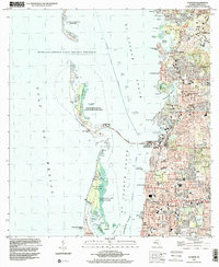
1998 Map of Dunedin
USGS Topo · Published 2001About this map
The Gulf Coast of Florida is defined here by its intricate barrier islands and expanding suburban developments at the close of the 20th century. Dunedin and Palm Harbor show significant residential density, with local landmarks like the Dunedin Marina and Trinity College serving as community anchors. The map illustrates the careful balance between development and preservation, with residential streets in Dunedin Isles and Crystal Beach sitting adjacent to protected landscapes like Caladesi Island State Park and the Honeymoon Island State Recreation Area.
Find a feature on this map
82 named features on this map. Tap any name to fly to it.
Don’t see what you’re looking for? This feature index may not catch every label — zoom into the map to look around manually.
Map Details
Editions of this 1998 Dunedin Map
This is the sole edition of this map. No revisions or reprints were ever made.
Other maps of this area

1921 · Sand Key
USGS Topo · 1:62,500

1921 · St Petersburg
USGS Topo · 1:62,500

1943 · Safety Harbor
USGS Topo · 1:31,680

1943 · Dunedin
USGS Topo · 1:31,680

1943 · Tarpon Springs
USGS Topo · 1:31,680

1943 · Clearwater
USGS Topo · 1:24,000

1943 · Elfers
USGS Topo · 1:24,000

1943 · Oldsmar
USGS Topo · 1:24,000

1944 · Elfers
USGS Topo · 1:31,680

1944 · Oldsmar
USGS Topo · 1:31,680