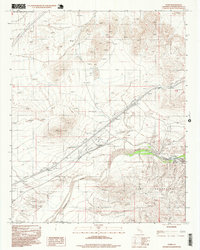
1996 Map of Dunn
USGS Topo · Published 1999About this map
The Mojave River cuts a prominent path through this high desert corridor, flanked by the Cady Mountains and the northern reaches of the Mojave. This late 20th-century landscape is defined by its role as a critical transit artery, where the Union Pacific railroad and a series of high-voltage Transmission Lines parallel the waterway. Remote outposts like Dunn and Afton serve as small anchors within this expanse of open terrain, which is bounded to the north by the Fort Irwin Military Reservation Boundary. Evidence of small-scale resource extraction is scattered throughout the hills, indicated by several Prospects and an isolated Mine. Near the river, the Afton Canyon Campground marks a rare point of public recreation, while a highway Rest Area and utility infrastructure like a Substation and various Tanks emphasize the region's support for interstate travel and regional power distribution.
Find a feature on this map
20 named features on this map. Tap any name to fly to it.
Don’t see what you’re looking for? This feature index may not catch every label — zoom into the map to look around manually.
Map Details
Editions of this 1996 Dunn Map
This is the sole edition of this map. No revisions or reprints were ever made.
Other maps of this area

1933 · Avawatz Mountains
USGS Topo · 1:250,000

1947 · Trona
USGS Topo · 1:250,000

1948 · Trona
USGS Topo · 1:250,000

1948 · Alvord Mountain
USGS Topo · 1:62,500

1948 · Cave Mountain
USGS Topo · 1:62,500

1951 · Cave Mountain
USGS Topo · 1:62,500

1951 · Alvord Mountain
USGS Topo · 1:62,500

1953 · San Bernardino
USGS Topo · 1:250,000

1953 · Trona
USGS Topo · 1:250,000

1955 · Newberry
USGS Topo · 1:62,500