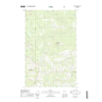
2020 Map of Dunsire Point
USGS Topo · Published 2020About this map
The Salish Mountains define this high-altitude landscape where the boundary between Lincoln and Flathead counties follows the primary drainage divides. The topography is dominated by prominent summits such as Mt Swaney and Dunsire Point, which serve as anchors for a complex network of ridgelines like Swaney Ridge and Elk Divide. This area within the Flathead National Forest and Kootenai National Forest showcases a classic mountain hydrology, with headwaters for Good Cr, Alder Cr, and Sheppard Cr flowing from the high slopes. The presence of numerous named forest roads, including Natl Forest Develop Road 282 RD and Natl Forest Develop Road 5397 RD, indicates a managed landscape where logging and forest access are primary human imprints. Geographical features such as Dunsire Pass and the Bowen Bench highlight the historic corridors used to navigate this terrain.
Find a feature on this map
48 named features on this map. Tap any name to fly to it.
Don’t see what you’re looking for? This feature index may not catch every label — zoom into the map to look around manually.
Map Details
Editions of this 2020 Dunsire Point Map
This is the sole edition of this map. No revisions or reprints were ever made.
Other maps of this area

1913 · Stryker
USGS Topo · 1:125,000

1916 · Stryker
USGS Topo · 1:125,000

1957 · Kalispell
USGS Topo · 1:250,000

1960 · Kalispell
USGS Topo · 1:250,000

1961 · Kalispell
USGS Topo · 1:250,000

1962 · Johnson Peak
USGS Topo · 1:24,000

1962 · Ashley Mountain
USGS Topo · 1:24,000

1963 · Sylvia Lake
USGS Topo · 1:24,000
1963 · Skillet Mountain
USGS Topo · 1:24,000

1963 · Sunday Mountain
USGS Topo · 1:24,000