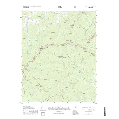
2019 Map of Dunsmore Mountain
USGS Topo · Published 2019About this map
Pisgah National Forest encompasses the majority of this territory, where the ridges of the Blue Ridge Mountains meet technical engineering along the Blue Ridge Pkwy. The survey details several significant mountain passages, including the Fork Mountain Tunnel and a series of three tunnels at Ferrin Knob. This 2019 data illustrates the complex topography of the Buncombe Co and Henderson Co border, showing how modern recreation trails like the Mountains To Sea Trail and the Explorer Loop wind through the same gaps and coves once navigated by early settlers. Local history is anchored by the O'Kelley Cem near Stony Fork and the Stuart Cem in the eastern hills. The drainage network is particularly detailed, tracing the headwaters of the North Mills River and Beaverdam Creek through numerous coves such as Ballard Cove and Billy Cove.
Find a feature on this map
138 named features on this map. Tap any name to fly to it.
Don’t see what you’re looking for? This feature index may not catch every label — zoom into the map to look around manually.
Map Details
Editions of this 2019 Dunsmore Mountain Map
This is the sole edition of this map. No revisions or reprints were ever made.
Other maps of this area

1894 · Asheville
USGS Topo · 1:125,000

1901 · Asheville
USGS Topo · 1:125,000

1905 · Pisgah
USGS Topo · 1:125,000

1906 · Pisgah
USGS Topo · 1:125,000

1935 · Cruso
USGS Topo · 1:24,000

1935 · Canton
USGS Topo · 1:24,000

1935 · Horse Shoe
USGS Topo · 1:24,000

1935 · Shining Rock
USGS Topo · 1:24,000

1935 · Pisgah Forest
USGS Topo · 1:24,000

1936 · Enka
USGS Topo · 1:24,000