
1936 Map of Dunsmore Mountain
USGS Topo · Published 1936About this map
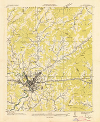
Buck Spring Lodge sits at the high western edge of this territory, overlooking a landscape defined by the drainage systems of Hominy Creek and the Mills River. This 1936 field examination, published as an advance sheet by the Tennessee Valley Authority and the Geological Survey, reveals a rural network of mountain life before modern development. Community centers are marked by small institutions like Stony Fork Sch and the Brownview Ch, while higher elevations feature monitoring points such as the Ferrin Knob Lookout Tower.
Find a feature on this map
136 named features on this map. Tap any name to fly to it.
Don’t see what you’re looking for? This feature index may not catch every label — zoom into the map to look around manually.
Map Details
Editions of this 1936 Dunsmore Mountain Map
This is the sole edition of this map. No revisions or reprints were ever made.
Other maps of this area

1894 · Asheville
USGS Topo · 1:125,000

1901 · Asheville
USGS Topo · 1:125,000

1905 · Pisgah
USGS Topo · 1:125,000

1906 · Pisgah
USGS Topo · 1:125,000

1935 · Cruso
USGS Topo · 1:24,000
1935 · Canton
USGS Topo · 1:24,000

1935 · Horse Shoe
USGS Topo · 1:24,000

1935 · Shining Rock
USGS Topo · 1:24,000

1935 · Pisgah Forest
USGS Topo · 1:24,000

1936 · Enka
USGS Topo · 1:24,000