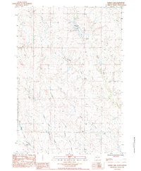
1983 Map of Durkee Lake
USGS Topo · Published 1984About this map
Durkee Lake serves as a primary water feature and gathering point in this portion of Meade County, South Dakota. This 1983 provisional survey highlights a landscape defined by a network of seasonal and permanent waterways, including Red Scaffold Creek and Spook Creek. The local topography is further shaped by the confluence of the North Branch Turtle Creek, East Branch Turtle Creek, and West Branch Turtle Creek.
Find a feature on this map
12 named features on this map. Tap any name to fly to it.
Don’t see what you’re looking for? This feature index may not catch every label — zoom into the map to look around manually.
Map Details
Editions of this 1983 Durkee Lake Map
This is the sole edition of this map. No revisions or reprints were ever made.
Other maps of this area

1953 · Rapid City
USGS Topo · 1:250,000

1953 · McIntosh
USGS Topo · 1:250,000

1954 · Lemmon
USGS Topo · 1:250,000

1954 · Pierre
USGS Topo · 1:250,000

1957 · Lemmon
USGS Topo · 1:250,000

1957 · Rapid City
USGS Topo · 1:250,000

1958 · Pierre
USGS Topo · 1:250,000

1958 · McIntosh
USGS Topo · 1:250,000

1982 · Chasing Hawk Draw
USGS Topo · 1:24,000

1982 · Bessie Butte
USGS Topo · 1:24,000