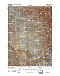
2011 Map of Dust Bowl
USGS Topo · Published 2011About this map
Verges Ranch and Barney Ranch anchor the high desert landscape of central Oregon in this 2011 survey. The terrain is defined by its evocative names, such as the Dust Bowl and Misery Flat, reflecting the challenging conditions of the region. The map captures a sparsely populated area where human presence is marked primarily by isolated ranching outposts and a few significant thoroughfares like Buck Creek Rd and Allen Rd.
Find a feature on this map
12 named features on this map. Tap any name to fly to it.
Don’t see what you’re looking for? This feature index may not catch every label — zoom into the map to look around manually.
Map Details
Editions of this 2011 Dust Bowl Map
This is the sole edition of this map. No revisions or reprints were ever made.
Other maps of this area

1955 · Crescent
USGS Topo · 1:250,000

1955 · Burns
USGS Topo · 1:250,000

1957 · Crescent
USGS Topo · 1:250,000

1958 · Crescent
USGS Topo · 1:250,000

1958 · Burns
USGS Topo · 1:250,000

1959 · Burns
USGS Topo · 1:250,000

1970 · Crescent
USGS Topo · 1:250,000

1981 · Hat Butte
USGS Topo · 1:24,000
1981 · Mackey Butte
USGS Topo · 1:24,000
1981 · Potato Hills
USGS Topo · 1:24,000