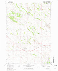
1981 Map of Potato Hills
USGS Topo · Published 1981About this map
The Potato Hills rise above a landscape defined by seasonal waterholes and expansive rangelands in this early 1980s look at Harney County. The presence of the Squaw Butte Range Experiment Station highlights the importance of agricultural research in this high-desert environment, where livestock and land management are central to the local economy. Settlement is focused at Gap Ranch and the nearby Gap Well, serving as a hub for the various 4WD trails that navigate the terrain between Juniper Ridge and the volcanic features of the area.
Find a feature on this map
24 named features on this map. Tap any name to fly to it.
Don’t see what you’re looking for? This feature index may not catch every label — zoom into the map to look around manually.
Map Details
Editions of this 1981 Potato Hills Map
This is the sole edition of this map. No revisions or reprints were ever made.
Other maps of this area

1955 · Burns
USGS Topo · 1:250,000

1958 · Burns
USGS Topo · 1:250,000

1959 · Burns
USGS Topo · 1:250,000

1980 · Squaw Butte
USGS Topo · 1:24,000

1980 · Round Top Butte
USGS Topo · 1:24,000

1980 · Hay Lake
USGS Topo · 1:24,000

1981 · Hat Butte
USGS Topo · 1:24,000
1981 · Dust Bowl
USGS Topo · 1:24,000
1981 · Bulger Ridge
USGS Topo · 1:24,000

1981 · Camp Currey Spring
USGS Topo · 1:24,000