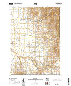
2020 Map of Dust Bowl
USGS Topo · Published 2020About this map
Gilchrist Valley and the evocatively named Dust Bowl sit at the intersection of Deschutes, Crook, and Harney Counties in central Oregon. This 2020 survey documents a high-desert landscape defined by seasonal drainages and remote access roads. The hydrology is marked by ephemeral features such as Swamp Creek, Bulger Creek, and Buck Creek, along with the isolated Juniper Spring. The presence of Misery Flat in the southwestern portion of the quadrangle suggests the difficult environmental conditions that historically challenged settlers and ranchers in this corner of the state. A sparse network of unpaved routes, including Schraeder Rd and Buck Creek Rd, provides the only infrastructure across these basin-and-range transitions.
Find a feature on this map
19 named features on this map. Tap any name to fly to it.
Don’t see what you’re looking for? This feature index may not catch every label — zoom into the map to look around manually.
Map Details
Editions of this 2020 Dust Bowl Map
This is the sole edition of this map. No revisions or reprints were ever made.
Other maps of this area

1955 · Crescent
USGS Topo · 1:250,000

1955 · Burns
USGS Topo · 1:250,000

1957 · Crescent
USGS Topo · 1:250,000

1958 · Crescent
USGS Topo · 1:250,000

1958 · Burns
USGS Topo · 1:250,000

1959 · Burns
USGS Topo · 1:250,000

1970 · Crescent
USGS Topo · 1:250,000

1981 · Hat Butte
USGS Topo · 1:24,000
1981 · Mackey Butte
USGS Topo · 1:24,000
1981 · Potato Hills
USGS Topo · 1:24,000