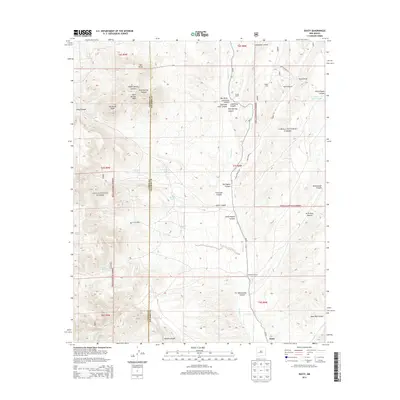
2013 Map of Dusty
USGS Topo · Published 2013About this map
Dusty serves as a small anchor for this rural landscape in the southwestern corner of Socorro County. The terrain is defined by a series of deep drainage systems, including Alamosa Cr and numerous rugged canyons such as Whitewater Canyon and Indian Spring Canyon. A complex network of ranching infrastructure is evident, with multiple family-named properties like the McCracken Ranch and Henderson Ranch scattered across the township lines. The influence of public land management is clear, as the map straddles the boundary between the Cibola National Forest and the Gila National Forest. Elevation high points like Rock Springs Peak and Patterson Peak overlook a system of water management features, including the Pigeon Windmill and several livestock tanks like Shreves Tank and New Tank. This remote area, accessed by Old State Hwy 52, reveals the persistence of high-desert ranching and the importance of scattered water sources in a landscape of dramatic topography.
Find a feature on this map
48 named features on this map. Tap any name to fly to it.
Don’t see what you’re looking for? This feature index may not catch every label — zoom into the map to look around manually.
Map Details
Editions of this 2013 Dusty Map
This is the sole edition of this map. No revisions or reprints were ever made.
Other maps of this area

1954 · Tularosa
USGS Topo · 1:250,000

1958 · Tularosa
USGS Topo · 1:250,000

1964 · Welty Hill
USGS Topo · 1:24,000

1964 · Bay Buck Peaks
USGS Topo · 1:24,000

1964 · Montoya Butte
USGS Topo · 1:24,000

1965 · Oak Peak
USGS Topo · 1:24,000

1965 · Dusty
USGS Topo · 1:24,000

1965 · Wahoo Peak
USGS Topo · 1:24,000

1979 · San Mateo Mountains
USGS Topo · 1:100,000
1981 · Luera Mountains East
USGS Topo · 1:24,000