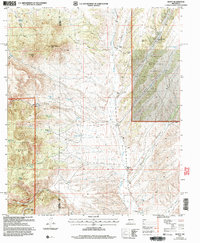
2005 Map of Dusty
USGS Topo · Published 2006About this map
Alamosa Creek carves a deep path through this New Mexico landscape at the boundary of Cibola National Forest and Gila National Forest. The settlement of Dusty sits in the southern portion of the quadrangle, serving as a rare anchor in a high-desert environment defined by ranching infrastructure and intermittent water sources. Evidence of the cattle industry is everywhere, from the McCracken Ranch Corral and Pigeon Cabin Corral to a vast network of water catchment systems such as Hells Tank, Shreves Tank, and Outlaw Tank. High points like Patterson Peak and Rock Springs Peak look down over the complex drainage patterns of Big Pigeon Canyon and Patterson Canyon. These labels indicate a geography shaped by family ranching and the pursuit of water in a territory where established trails and 4wd tracks provide the primary means of traversal between remote outposts like Tucker Ranch and Henderson Ranch.
Find a feature on this map
37 named features on this map. Tap any name to fly to it.
Don’t see what you’re looking for? This feature index may not catch every label — zoom into the map to look around manually.
Map Details
Editions of this 2005 Dusty Map
This is the sole edition of this map. No revisions or reprints were ever made.
Other maps of this area

1954 · Tularosa
USGS Topo · 1:250,000

1958 · Tularosa
USGS Topo · 1:250,000

1964 · Welty Hill
USGS Topo · 1:24,000

1964 · Bay Buck Peaks
USGS Topo · 1:24,000

1964 · Montoya Butte
USGS Topo · 1:24,000

1965 · Oak Peak
USGS Topo · 1:24,000

1965 · Dusty
USGS Topo · 1:24,000

1965 · Wahoo Peak
USGS Topo · 1:24,000

1979 · San Mateo Mountains
USGS Topo · 1:100,000
1981 · Luera Mountains East
USGS Topo · 1:24,000