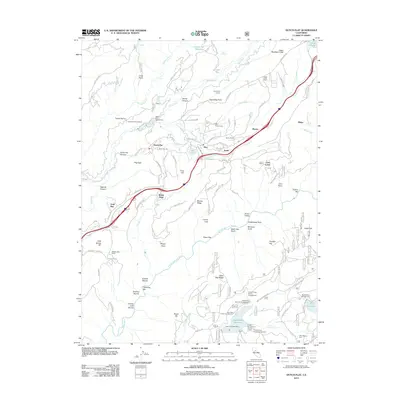
2012 Map of Dutch Flat
USGS Topo · Published 2012About this map
Dutch Flat sits at the heart of this Sierra Nevada landscape, where hydraulic mining legacies and hydroelectric infrastructure define the modern topography. The settlement is flanked by the Dutch Flat Cem and the complex water delivery systems of the Pulp Mill Ditch and the Dutch Flat Tunnel. This geography illustrates the long-term evolution of Gold Country resource management, from the early excavations of Dutch Flat Canyon to the massive energy works of the Alta Powerhouse and Dutch Flat Powerhouse. To the south, the deep gorge of the N Fork American River cuts through the terrain at Giant Gap, a stark contrast to the modern recreational spaces of the Sugar Pine Reservoir and Forbes Campground. The map also traces the historic path of the Lincoln Rd as it connects old mining towns like Gold Run and Monte Vista to the higher elevations of Alta and Baxter.
Find a feature on this map
102 named features on this map. Tap any name to fly to it.
Don’t see what you’re looking for? This feature index may not catch every label — zoom into the map to look around manually.
Map Details
Editions of this 2012 Dutch Flat Map
This is the sole edition of this map. No revisions or reprints were ever made.
Other maps of this area

1891 · Colfax
USGS Topo · 1:125,000

1892 · Colfax
USGS Topo · 1:125,000

1894 · Colfax
USGS Topo · 1:125,000

1898 · Colfax
USGS Topo · 1:125,000

1900 · Colfax
USGS Topo · 1:125,000

1902 · Colfax
USGS Topo · 1:125,000

1938 · Colfax
USGS Topo · 1:125,000
1948 · Foresthill
USGS Topo · 1:24,000
1949 · Colfax
USGS Topo · 1:24,000

1949 · Chicago Park
USGS Topo · 1:24,000