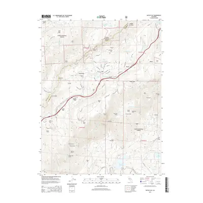
2015 Map of Dutch Flat
USGS Topo · Published 2015About this map
Gold Run and Dutch Flat anchor this survey of the Sierra Nevada foothills, a landscape defined by its complex water systems and deep canyons. The map tracks the passage of the Boardman Canal and the Pulp-Mill-Ditch across high ridges like Moody Ridge and Chalk Bluff Ridge, while the North Fork American River carves through Giant Gap. This geography reveals a legacy of hydraulic infrastructure, where reservoirs like Sugar Pine Reservoir and Lake Alta support the region. Local history is grounded in the Dutch Flat Cemetery and the Alta School, providing specific points of interest for genealogists. The terrain is marked by named ravines and points such as Sheldon Ravine and Bogus Point, reflecting a history of mining and timber work that connected small settlements like Alta, Towle, and Baxter along the ridgelines.
Find a feature on this map
91 named features on this map. Tap any name to fly to it.
Don’t see what you’re looking for? This feature index may not catch every label — zoom into the map to look around manually.
Map Details
Editions of this 2015 Dutch Flat Map
This is the sole edition of this map. No revisions or reprints were ever made.
Other maps of this area

1891 · Colfax
USGS Topo · 1:125,000

1892 · Colfax
USGS Topo · 1:125,000

1894 · Colfax
USGS Topo · 1:125,000

1898 · Colfax
USGS Topo · 1:125,000

1900 · Colfax
USGS Topo · 1:125,000

1902 · Colfax
USGS Topo · 1:125,000

1938 · Colfax
USGS Topo · 1:125,000
1948 · Foresthill
USGS Topo · 1:24,000
1949 · Colfax
USGS Topo · 1:24,000

1949 · Chicago Park
USGS Topo · 1:24,000