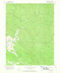
1966 Map of Dutchmans Knoll
USGS Topo · Published 1969About this map
The rugged interior of Mendocino County is defined by the winding course of the Ten Mile River and its numerous tributaries during the mid-1960s. The landscape is a network of named ridges including Bucha Ridge, Smith Ridge, and Ramsey Ridge, which separate deep drainages such as Bear Haven Creek and Smith Creek. Human presence is sparse, marked primarily by isolated agricultural and resource sites like O'Conner Orchard and a Gravel Pit in the southwest near Little Valley Creek.
Find a feature on this map
34 named features on this map. Tap any name to fly to it.
Don’t see what you’re looking for? This feature index may not catch every label — zoom into the map to look around manually.
Map Details
Editions of this 1966 Dutchmans Knoll Map
3 editions found
Other maps of this area

1920 · Glenblair
USGS Topo · 1:62,500

1920 · Fort Bragg
USGS Topo · 1:62,500

1921 · Westport
USGS Topo · 1:62,500

1921 · Branscomb
USGS Topo · 1:62,500

1943 · Glenblair
USGS Topo · 1:62,500

1943 · Fort Bragg
USGS Topo · 1:62,500

1950 · Cape Vizcaino
USGS Topo · 1:62,500

1951 · Cape Vizcaino
USGS Topo · 1:62,500

1951 · Branscomb
USGS Topo · 1:62,500

1957 · Ukiah
USGS Topo · 1:250,000