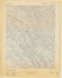
1966 Map of Dutchmans Knoll
USGS Topo · Published 1966About this map
Dutchmans Knoll stands as a primary landmark in this rugged section of the Mendocino coast, where the land is defined by a dense network of drainages and timber access. The landscape is dominated by the Ten Mile River and its numerous tributaries, including Middle Fork and Smith Creek, which carve deep valleys between high points like Smith Ridge and Ramsey Ridge. A Ten Mile Private Road provides the main artery through the complex terrain, suggesting the area's reliance on private industry and resource extraction during this era.
Find a feature on this map
33 named features on this map. Tap any name to fly to it.
Don’t see what you’re looking for? This feature index may not catch every label — zoom into the map to look around manually.
Map Details
Editions of this 1966 Dutchmans Knoll Map
3 editions found
Other maps of this area

1920 · Glenblair
USGS Topo · 1:62,500

1920 · Fort Bragg
USGS Topo · 1:62,500

1921 · Westport
USGS Topo · 1:62,500

1921 · Branscomb
USGS Topo · 1:62,500

1943 · Glenblair
USGS Topo · 1:62,500

1943 · Fort Bragg
USGS Topo · 1:62,500

1950 · Cape Vizcaino
USGS Topo · 1:62,500

1951 · Cape Vizcaino
USGS Topo · 1:62,500

1951 · Branscomb
USGS Topo · 1:62,500

1957 · Ukiah
USGS Topo · 1:250,000