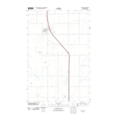
2011 Map of Dutton
USGS Topo · Published 2011About this map
Dutton serves as the primary hub for this Teton County landscape, where the concentrated infrastructure of the Dutton Post Office, Dutton Vol Fire Dept, and Dutton Airport meet the wide expanse of the Montana prairie. The town's layout is defined by a grid of grain avenues and numbered roads, a testament to the region's agricultural roots. Beyond the town center, the terrain is marked by significant geographic features like Bosseler Ridge and Teton Ridge, which overlook the winding path of Muddy Creek. Small-scale water management is evident through features such as Thav Dam and Robbie Dam, essential for the ranching and farming operations that dominate the area. This 2011 survey provides a clear view of the intersection between the modern Interstate corridor and the long-established rural landmarks like the Dutton Cemetery, offering a detailed perspective on the community's spatial organization.
Find a feature on this map
30 named features on this map. Tap any name to fly to it.
Don’t see what you’re looking for? This feature index may not catch every label — zoom into the map to look around manually.
Map Details
Editions of this 2011 Dutton Map
This is the sole edition of this map. No revisions or reprints were ever made.
Other maps of this area

1886 · Great Falls
USGS Topo · 1:250,000

1949 · Vaughn
USGS Topo · 1:62,500

1950 · Fairfield
USGS Topo · 1:62,500

1950 · Dutton
USGS Topo · 1:62,500

1950 · Collins
USGS Topo · 1:62,500

1952 · Vaughn
USGS Topo · 1:62,500

1954 · Great Falls
USGS Topo · 1:250,000

1957 · Great Falls
USGS Topo · 1:250,000

1976 · Great Falls North
USGS Topo · 1:100,000
1983 · Vaughn NE
USGS Topo · 1:24,000