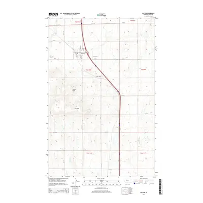
2014 Map of Dutton
USGS Topo · Published 2014About this map
Dutton serves as the focal point of this Teton County landscape, situated where MT-221 meets 1-15 S. This region is defined by a grid of agricultural section lines and significant topographical features like Teton Ridge and Bosseler Ridge. The settlement is supported by the nearby Dutton Airport and the Dutton Cem located just north of the town center. The drainage of Muddy Cr and several named coulees, including Railroad Coulee and Hunt Coulee, carve through the high plains, illustrating the natural water management of the Montana prairie. This map provides a clear view of the transportation corridors and township boundaries, including t24n r1w and t24n r1e, that organize the ranching and farming operations of the modern era.
Find a feature on this map
29 named features on this map. Tap any name to fly to it.
Don’t see what you’re looking for? This feature index may not catch every label — zoom into the map to look around manually.
Map Details
Editions of this 2014 Dutton Map
This is the sole edition of this map. No revisions or reprints were ever made.
Other maps of this area

1886 · Great Falls
USGS Topo · 1:250,000

1949 · Vaughn
USGS Topo · 1:62,500

1950 · Fairfield
USGS Topo · 1:62,500

1950 · Dutton
USGS Topo · 1:62,500

1950 · Collins
USGS Topo · 1:62,500

1952 · Vaughn
USGS Topo · 1:62,500

1954 · Great Falls
USGS Topo · 1:250,000

1957 · Great Falls
USGS Topo · 1:250,000

1976 · Great Falls North
USGS Topo · 1:100,000
1983 · Vaughn NE
USGS Topo · 1:24,000